Mountwest Community and Technical College, Huntington
Map
Facts and practical information
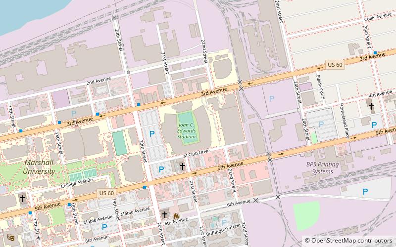
Mountwest Community and Technical College is a public community college in Huntington, West Virginia. It is one of ten regional community colleges in the West Virginia Community and Technical College System. ()
Coordinates: 38°25'30"N, 82°25'14"W
Getting there by public transportation
Public transportation stops near this location
- Bus
- Train
 Bus
Bus
- Calculate route3rd Avenue & 20th Street & Marshall Stadium 4 min walk
- Calculate route5th Avenue & 20th Street 5 min walk
- Calculate routeHuntington 32 min walk
Day trips
Mountwest Community and Technical College – popular in the area (distance from the attraction)
Nearby attractions include: Joan C. Edwards Stadium, Keith-Albee Theatre, Marshall University, B'nai Sholom Congregation.


Frequently Asked Questions (FAQ)
Which popular attractions are close to Mountwest Community and Technical College?
Nearby attractions include Marshall University, Huntington (1 min walk), Joan C. Edwards Stadium, Huntington (1 min walk), Marshall University, Huntington (14 min walk), Simms School Building, Huntington (22 min walk).
How to get to Mountwest Community and Technical College by public transport?
The nearest stations to Mountwest Community and Technical College:
Bus
Train
Bus
- 3rd Avenue & 20th Street & Marshall Stadium • Lines: 3 (4 min walk)
- 5th Avenue & 20th Street • Lines: 3 (5 min walk)
Train
- Huntington (32 min walk)