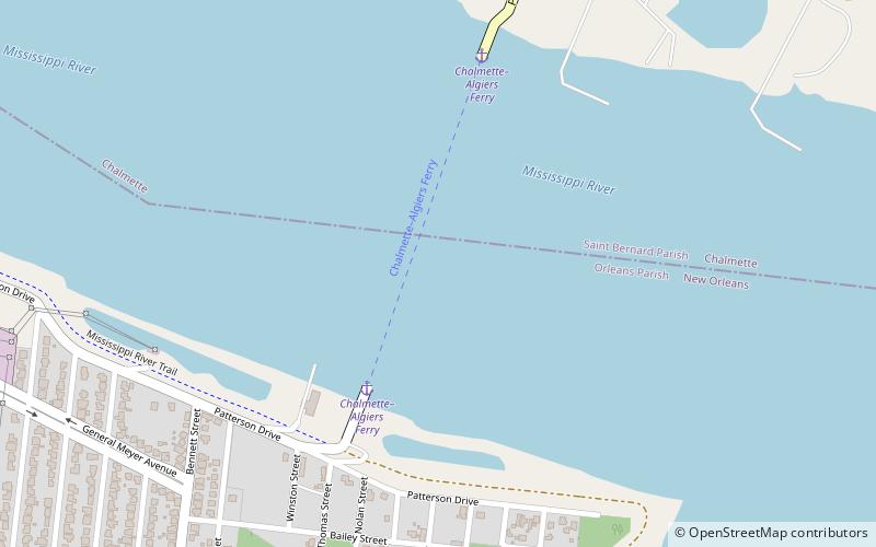
Chalmette – Lower Algiers Ferry, New Orleans
#215 among attractions in New Orleans
![Chalmette – Lower Algiers Ferry location map](https://tzmedia.b-cdn.net/media/images/static-maps/us/29_924_-89_972.jpg)
Facts and practical information
The Chalmette–Lower Algiers Ferry is a ferry across the Mississippi River in the U.S. state of Louisiana, connecting Chalmette and Algiers. ()
Paris RdNew Orleans 70043 United States
Popular hours based on visits to this place ExpandHide
New Orleans plan & book
Unleash the traveler in you — discover the cheapest flight deals, find the perfect hotel or hostel nearby, and search for the best car rental prices. Travel at your own pace to discover new places and enjoy your journey.
Chalmette – Lower Algiers Ferry – popular in the area (distance from the attraction)
Nearby attractions include: Oakwood Center, Chalmette monument, Chalmette National Cemetery, Jackson Barracks.
4 miWShopping, Shopping centreOakwood Center, New Orleans
103 min walk • Oakwood Center is a major shopping mall in Terrytown, Louisiana, on the West Bank of the Mississippi River in the New Orleans metropolitan area. It was originally named "Oakwood Mall", and some signage and local usage continue to call it that. It is geographically in Terrytown, but the mailing address is in adjacent Gretna, Louisiana.
1.8 miNWMuseum, History museum, National parkChalmette monument, New Orleans
47 min walk • Jean Lafitte National Historical Park and Preserve protects the natural and cultural resources of Louisiana's Mississippi River Delta region. It is named after French pirate Jean Lafitte and consists of six separate sites and a park headquarters.
1.5 miNWCemeteryChalmette National Cemetery, Chalmette
39 min walk • Chalmette National Cemetery is a United States National Cemetery located within Jean Lafitte National Historical Park and Preserve in Chalmette, Louisiana.
3 miNWNeighbourhoodJackson Barracks, New Orleans
76 min walk • Jackson Barracks is the headquarters of the Louisiana National Guard. It is located in the Lower 9th Ward of New Orleans, Louisiana. The base was established in 1834 and was originally known as New Orleans Barracks. On July 7, 1866, it was renamed in honor of Andrew Jackson.
4.3 miNWBridgeSt. Claude Avenue Bridge, New Orleans
110 min walk • The St. Claude Avenue Bridge is a bascule bridge with four vehicular lanes over the Industrial Canal in New Orleans, Louisiana.
4.4 miNWCanal, Boat or ferryIndustrial Canal Lock, New Orleans
112 min walk • The Inner Harbor Navigation Canal Lock—commonly known as Industrial Canal Lock or simply Industrial Lock—is a navigation lock in New Orleans. It connects the Lower Mississippi River to the Industrial Canal and other sea-level waterways.
5 miW29°57'4"N • 90°2'56"WRosetree Glass Studio and Gallery, New Orleans
127 min walk • Museum, Art gallery, Shopping
4.2 miNW29°57'53"N • 90°1'24"WLower 9th Ward Living Museum, New Orleans
107 min walk • Museum, History museum
1.8 miNWHistorical place, Architecture, BattlefieldRene Beauregard House, Chalmette
45 min walk • Rene Beauregard House, also known as the Malus-Beauregard House, is an 1830s porticoed mansion, an example of French-Louisiana architecture, overlooking the Battle of New Orleans battlefield.
2.9 miNCanalFlorida Canal, New Orleans
73 min walk • The Florida Canal or 40 Arpent Canal is a canal in the New Orleans metropolitan area and land down river.
2.5 miNWColonial revival architectureFriscoville Street Historic District, New Orleans
65 min walk • The Friscoville Street Historic District, in Arabi, Louisiana in St. Bernard Parish, Louisiana, is a 16 acres historic district which was listed on the National Register of Historic Places in 1998. It included 76 contributing buildings.