Conestoga Creek Viaduct, Lancaster
Facts and practical information
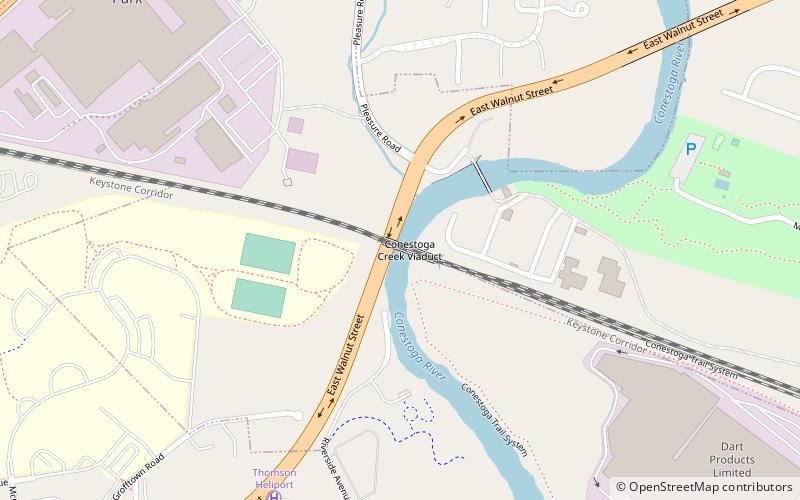
The Conestoga Creek Viaduct spans the Conestoga River east of Lancaster, Pennsylvania. The present structure, built in 1887–88, is a five-span, two-track stone arch railroad bridge. The first crossing at this location was a 1,412 feet series of 11 wooden Town lattice trusses constructed in 1829 for the Columbia and Philadelphia Railroad, which was purchased by the Pennsylvania Railroad and incorporated into its main line in 1857. PRR shortened the viaduct and replaced the remaining wooden trusses with iron Whipple trusses in 1863. The 1887-88 stone arch replacement was originally intended to be four tracks wide, but only half of the superstructure width was constructed, leaving an unfinished spandrel wall on the southern face. Tie rods were added in 1930 to brace the spandrel walls. ()
Lancaster
- Bus
 Bus
Bus
- Calculate routeEast Ross and New Holland Avenue 18 min walk
- Calculate routeHamilton Street and North Reservoir Street 21 min walk
- Calculate routeNew Holland Avenue and North Franklin Street 22 min walk


Frequently Asked Questions (FAQ)
Which popular attractions are close to Conestoga Creek Viaduct?
How to get to Conestoga Creek Viaduct by public transport?
Bus
- East Ross and New Holland Avenue • Lines: 2 (18 min walk)
- Hamilton Street and North Reservoir Street • Lines: 2 (21 min walk)