Denver Federal Center, Denver
Map
Facts and practical information
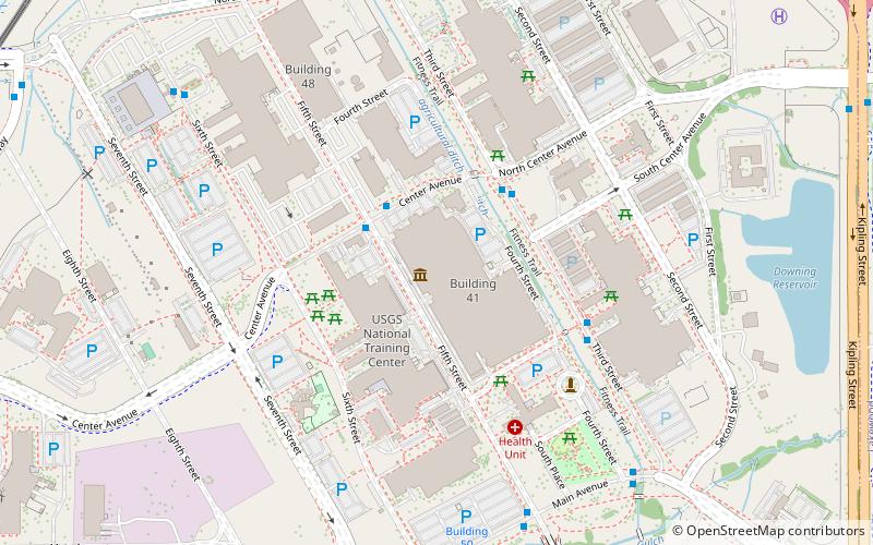
The Denver Federal Center, in Lakewood, Colorado, is part of the General Services Administration and is home to about 6,200 employees of agencies of the federal government of the United States. The Center encompasses an area of about 670 acres and has 90 buildings with over 4,000,000 square feet of office, warehouse, lab and special use space. There are 28 different Federal agencies on-site, making it the largest concentration of Federal agencies outside of Washington, D.C. ()
Coordinates: 39°43'11"N, 105°7'5"W
Address
Union SquareDenver
ContactAdd
Social media
Add
Getting there by public transportation
Public transportation stops near this location
- Bus
- Light rail
 Bus
Bus
- Calculate routeFederal Center Gate N 15 min walk
- Calculate routeFederal Center Gate L 16 min walk
- Calculate routeWest Alameda Avenue & South Moore Street 16 min walk
- Calculate routeFederal Center 15 min walk
- Calculate routeGarrison 39 min walk
Day trips


Frequently Asked Questions (FAQ)
How to get to Denver Federal Center by public transport?
The nearest stations to Denver Federal Center:
Bus
Light rail
Bus
- Federal Center Gate N • Lines: 3 (15 min walk)
- Federal Center Gate L • Lines: CDOT Bustang, CDOT Bustang Outrider (16 min walk)
Light rail
- Federal Center • Lines: W (15 min walk)
- Garrison • Lines: W (39 min walk)