The Endup, San Francisco

Facts and practical information
Nestled in the vibrant heart of San Francisco's SoMa district, The Endup is a nightclub that has become an iconic fixture of the city's nightlife scene. Known for its eclectic mix of music and inclusive atmosphere, this venue has been a pulsating hub for revelers since it first opened its doors in the 1970s.
The Endup is famed for its dance floor that welcomes everyone from the after-hours crowd to the Sunday afternoon T-dance partygoers. With a history steeped in the city's diverse cultural tapestry, the club has seen generations of party enthusiasts pass through its doors, seeking the electric energy that The Endup consistently delivers.
Characterized by its unassuming exterior, the club reveals its true colors once you step inside. The interior space is designed to immerse guests in a world of sound and rhythm, with state-of-the-art sound systems and lighting that transform the space into a dynamic backdrop for unforgettable nights.
The venue boasts an outdoor patio, a rarity in San Francisco's nightclub landscape, which offers a more relaxed environment where guests can converse and enjoy the city's temperate climate. This feature, combined with the club's reputation for hosting a variety of local and international DJs, contributes to The Endup's status as a beloved institution in San Francisco's entertainment offerings.
Open until the early hours of the morning, The Endup is a sanctuary for those looking to extend their night out. It's a place where the music doesn't stop until the sun comes up, providing a home for the city's night owls and those who dance to the beat of their own drum.
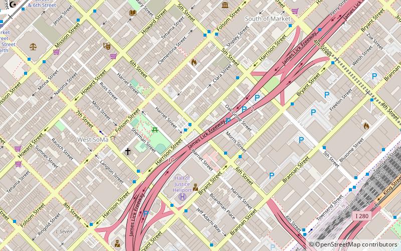
401 6th StSoutheast San Francisco (South of Market)San Francisco
- Metro
- Bus
- Trolleybus
- Tram
- Light rail
- Train
 Metro
Metro
- Calculate routeHarrison Street & 6th Street 1 min walk
- Calculate routeBryant Street & 6th Street 4 min walk
- Calculate route7th Street & Harrison Street 5 min walk
- Calculate route4th Street & Folsom Street 9 min walk
- Calculate routeMission Street & 6th Street 10 min walk
- Calculate routeSan Francisco 4th & King Street 13 min walk
- Calculate routeMarket Street & 6th Street 13 min walk
- Calculate routeKing Street & 4th Street 13 min walk
- Calculate routePowell Street 14 min walk
- Calculate routeCivic Center 15 min walk
- Calculate route4th Street & King Street 15 min walk
- Calculate routePowell Street 14 min walk
- Calculate routeCivic Center 15 min walk
 Muni Metro


Frequently Asked Questions (FAQ)
Which popular attractions are close to The Endup?
How to get to The Endup by public transport?
Bus
- Harrison Street & 6th Street • Lines: 8 (1 min walk)
- Bryant Street & 6th Street • Lines: 8 (4 min walk)
Trolleybus
- 4th Street & Folsom Street • Lines: 30, 45 (9 min walk)
- Mission Street & 6th Street • Lines: 14 (10 min walk)
Train
- San Francisco 4th & King Street (13 min walk)
Tram
- Market Street & 6th Street • Lines: F (13 min walk)
Light rail
- King Street & 4th Street • Lines: N, S (13 min walk)
- Powell Street • Lines: K, N, S, T (14 min walk)
Metro
- Powell Street • Lines: Blue, Green, Red, Yellow (14 min walk)
- Civic Center • Lines: Blue, Green, Red, Yellow (15 min walk)