Trocadero Transfer, San Francisco

Gallery (1)
Map
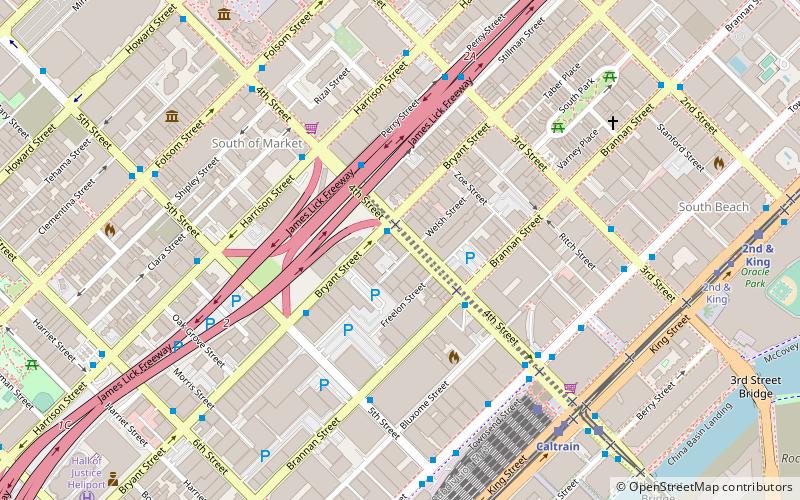
Map
Facts and practical information
The Trocadero Transfer was an after hours dance club in San Francisco from its opening in December 1977 to the late 1990s. It was located at 520 4th Street at Bryant in the SoMa neighborhood. In 2000, the club was bought by a new owner, remodeled, and renamed to the Glas Kat. In late 2011, the club was again remodeled, and the name was changed to The Grand. ()
Coordinates: 37°46'45"N, 122°23'52"W
Address
Southeast San Francisco (South of Market)San Francisco
ContactAdd
Social media
Add
Getting there by public transportation
Public transportation stops near this location
- Metro
- Bus
- Trolleybus
- Tram
- Light rail
- Train
- Ferry
 Metro
Metro
- Calculate routeBryant Street & 4th Street 1 min walk
- Calculate route4th Street & Brannan Street 3 min walk
- Calculate routePerry Street & 4th Street 3 min walk
- Calculate route3rd Street & Perry Street 6 min walk
- Calculate routeTownsend Street & 4th Street 6 min walk
- Calculate route4th Street & Folsom Street 7 min walk
- Calculate routeSan Francisco 4th & King Street 7 min walk
- Calculate routeKing Street & 4th Street 8 min walk
- Calculate route4th Street & King Street 9 min walk
- Calculate route2nd & King 11 min walk
- Calculate routeMission Rock 16 min walk
- Calculate routeMarket Street & 4th Street 17 min walk
- Calculate routePowell Street 17 min walk
- Calculate routeMontgomery Street 19 min walk
- Calculate routeCivic Center 23 min walk
- Calculate routeFerry Building Gate G 29 min walk
Maps Muni Metro
Muni MetroDay trips


Frequently Asked Questions (FAQ)
Which popular attractions are close to Trocadero Transfer?
Nearby attractions include Gallery 16, San Francisco (6 min walk), American Bookbinders Museum, San Francisco (9 min walk), Children's Creativity Museum, San Francisco (10 min walk), Hosfelt Gallery, San Francisco (11 min walk).
How to get to Trocadero Transfer by public transport?
The nearest stations to Trocadero Transfer:
Bus
Trolleybus
Train
Light rail
Tram
Metro
Ferry
Bus
- Bryant Street & 4th Street • Lines: 8 (1 min walk)
- 4th Street & Brannan Street • Lines: 91 (3 min walk)
Trolleybus
- 3rd Street & Perry Street • Lines: 30, 45 (6 min walk)
- Townsend Street & 4th Street • Lines: 30, 45 (6 min walk)
Train
- San Francisco 4th & King Street (7 min walk)
Light rail
- King Street & 4th Street • Lines: N, S (8 min walk)
- 4th Street & King Street • Lines: T (9 min walk)
Tram
- Market Street & 4th Street • Lines: F (17 min walk)
Metro
- Powell Street • Lines: Blue, Green, Red, Yellow (17 min walk)
- Montgomery Street • Lines: Blue, Green, Red, Yellow (19 min walk)
Ferry
- Ferry Building Gate G • Lines: San Francisco Bay Ferry (29 min walk)