Golf View Estates, Lexington
Map
Facts and practical information
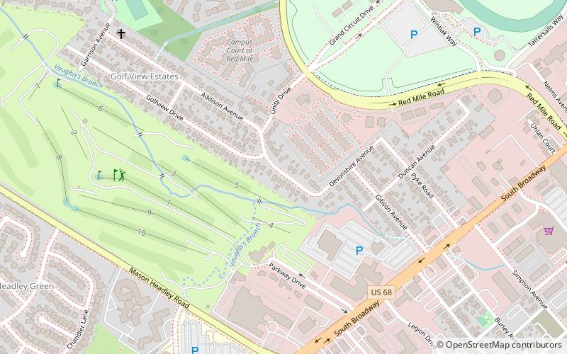
Golf View Estates is a neighborhood in southwestern Lexington, Kentucky, United States. Its name is derived from its location next to the Campbell House golf course. Its boundaries are the Campbell House and its golf course to the south, Addison Park to the west, Red Mile Road to the north, and South Broadway to the east. ()
Coordinates: 38°2'17"N, 84°31'26"W
Address
Lexington
ContactAdd
Social media
Add
Getting there by public transportation
Public transportation stops near this location
- Bus
 Bus
Bus
- Calculate route1366 - Nicholasville @ Forest Park Outbound 26 min walk
- Calculate route1624 Cooper @ Science Building Inbound 27 min walk
- Calculate route1389 Nicholasville @ Farm Inbound 28 min walk
- Calculate route1367 - Nicholasville @ Dantzler Outbound 31 min walk
Day trips


Frequently Asked Questions (FAQ)
Which popular attractions are close to Golf View Estates?
Nearby attractions include Lexington Parks and Recreation Center, Lexington (5 min walk), The Red Mile, Lexington (11 min walk), Burley Park, Lexington (11 min walk), Headley Green, Lexington (12 min walk).
How to get to Golf View Estates by public transport?
The nearest stations to Golf View Estates:
Bus
Bus
- 1366 - Nicholasville @ Forest Park Outbound • Lines: 16 Southland Dr, 5, 5 Nicholasville Road (26 min walk)
- 1624 Cooper @ Science Building Inbound • Lines: 16 Southland Dr (27 min walk)