Shirley Ann Place, San Diego
Map
Facts and practical information
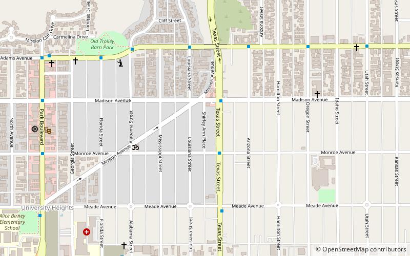
Shirley Ann Place is a one-block-long street in the University Heights neighborhood of San Diego, California. The block, between Madison Ave. and Monroe Ave. and west of Texas Street, was designated the Shirley Ann Place Historic District by the City of San Diego for its 1920s Spanish Colonial Revival bungalows. ()
Coordinates: 32°45'36"N, 117°8'22"W
Address
Western San Diego (University Heights)San Diego
ContactAdd
Social media
Add
Getting there by public transportation
Public transportation stops near this location
- Bus
- Light rail
 Bus
Bus
- Calculate routeFlixBus San Diego Mission Valley 20 min walk
- Calculate routeRio Vista 25 min walk
- Calculate routeMission Valley Center 25 min walk
- Calculate routeHazard Center 34 min walk
Day trips


Frequently Asked Questions (FAQ)
Which popular attractions are close to Shirley Ann Place?
Nearby attractions include El Cajon Boulevard, San Diego (13 min walk), Roman Catholic Diocese of San Diego, San Diego (16 min walk), Mission Valley, San Diego (21 min walk).
How to get to Shirley Ann Place by public transport?
The nearest stations to Shirley Ann Place:
Bus
Light rail
Bus
- FlixBus San Diego Mission Valley • Lines: 2016, N2003 (20 min walk)
Light rail
- Rio Vista • Lines: 530 (25 min walk)
- Mission Valley Center • Lines: 530 (25 min walk)