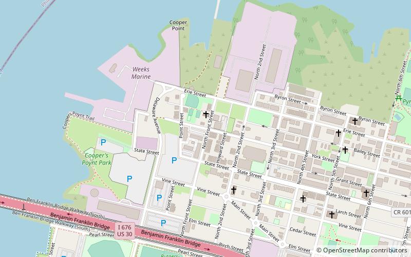
Cooper Point, Camden
Map
Facts and practical information
Cooper Point is a neighborhood in the northwestern part of Camden, New Jersey, United States. According to the 2000 U.S. Census, the neighborhood has a population of 2,880. It is north of Cooper Grant and the Central Waterfront the other neighborhoods located near the Ben Franklin Bridge. ()
Coordinates: 39°57'18"N, 75°7'26"W
Address
Cooper PointCamden
ContactAdd
Social media
Add
Getting there by public transportation
Public transportation stops near this location
- Metro
- Bus
- Tram
- Light rail
 Metro
Metro
- Calculate routeCooper Street–Rutgers 13 min walk
- Calculate routeAdventure Aquarium 18 min walk
- Calculate routeWalter Rand Transportation Center 22 min walk
- Calculate routeEntertainment Center 26 min walk
- Calculate routeCity Hall 17 min walk
- Calculate routeBroadway 22 min walk
- Calculate routeSpring Garden 25 min walk
- Calculate route2nd Street 29 min walk
- Calculate routeWalter Rand Transportation Center 22 min walk
- Calculate routeFrankford Avenue & Delaware Avenue 23 min walk
- Calculate routeGirard Avenue & Front Street 30 min walk
Day trips


Frequently Asked Questions (FAQ)
Which popular attractions are close to Cooper Point?
Nearby attractions include Campbell's Field, Camden (10 min walk), Nipper Building, Camden (11 min walk), Rutgers University–Camden, Camden (11 min walk), Cooper Library in Johnson Park, Camden (13 min walk).
How to get to Cooper Point by public transport?
The nearest stations to Cooper Point:
Light rail
Metro
Bus
Tram
Light rail
- Cooper Street–Rutgers • Lines: River Line (13 min walk)
- Adventure Aquarium • Lines: River Line (18 min walk)
Metro
- City Hall • Lines: Patco (17 min walk)
- Broadway • Lines: Patco (22 min walk)
Bus
- Walter Rand Transportation Center (22 min walk)
Tram
- Frankford Avenue & Delaware Avenue • Lines: 15 (23 min walk)
- Girard Avenue & Front Street • Lines: 15 (30 min walk)