Punch Line San Francisco, San Francisco

Gallery (1)
Map
Map
Facts and practical information
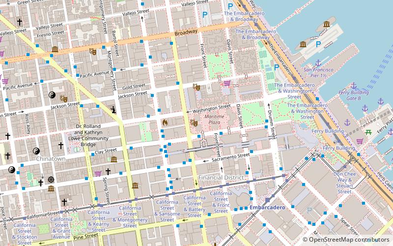
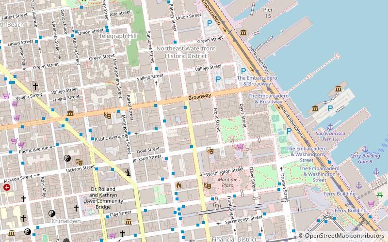
Punch Line San Francisco is a comedy club located at 444 Battery St in San Francisco's Financial District. It has a sister club in Sacramento, California, and is also associated with Cobb's Comedy Club, now in the North Beach neighborhood of San Francisco. It is San Francisco's oldest running comedy club. ()
Coordinates: 37°47'44"N, 122°24'0"W
Address
444 Battery StreetNortheast San Francisco (Financial District)San Francisco
Contact
+1 415-397-7573
Social media
Add
Getting there by public transportation
Public transportation stops near this location
- Metro
- Bus
- Trolleybus
- Tram
- Light rail
- Ferry
 Metro
Metro
- Calculate routeClay Street & Front Street 2 min walk
- Calculate routeSacramento Street & Sansome Street 4 min walk
- Calculate routeClay Street & Front Street 2 min walk
- Calculate routeBattery Street & Sacramento Street 3 min walk
- Calculate routeSansome Street & Clay Street 3 min walk
- Calculate routeSansome Street & Washington Street 3 min walk
- Calculate routeCalifornia Street & Battery Street 5 min walk
- Calculate routeCalifornia Street & Front Street 5 min walk
- Calculate routeCalifornia Street & Sansome Street 5 min walk
- Calculate routeCalifornia Street & Davis Street 5 min walk
- Calculate routeEmbarcadero 7 min walk
- Calculate routeMontgomery Street 12 min walk
- Calculate routeFolsom 18 min walk
- Calculate routePowell Street 23 min walk
- Calculate routeEmbarcadero 7 min walk
- Calculate routeMontgomery Street 12 min walk
- Calculate routePowell Street 22 min walk
- Calculate routeFerry Building Gate B 10 min walk
- Calculate routePier 41 Gate 2 30 min walk
Maps Muni Metro
Muni MetroDay trips


Frequently Asked Questions (FAQ)
Which popular attractions are close to Punch Line San Francisco?
Nearby attractions include Bank of Italy Building, San Francisco (1 min walk), One Maritime Plaza, San Francisco (2 min walk), One Embarcadero Center, San Francisco (2 min walk), Bently Reserve, San Francisco (3 min walk).
How to get to Punch Line San Francisco by public transport?
The nearest stations to Punch Line San Francisco:
Trolleybus
Bus
Tram
Light rail
Metro
Ferry
Trolleybus
- Clay Street & Front Street • Lines: 1 (2 min walk)
- Sacramento Street & Sansome Street • Lines: 1 (4 min walk)
Bus
- Clay Street & Front Street • Lines: 27, 4 (2 min walk)
- Battery Street & Sacramento Street • Lines: 18, 2, 24, 24X, 27, 38, 38A, 4, 54, 56X, 58, 72, 72X, 74, 76, 8 (3 min walk)
Tram
- California Street & Battery Street (5 min walk)
- California Street & Front Street (5 min walk)
Light rail
- Embarcadero • Lines: K, N, S, T (7 min walk)
- Montgomery Street • Lines: K, N, S, T (12 min walk)
Metro
- Embarcadero • Lines: Blue, Green, Red, Yellow (7 min walk)
- Montgomery Street • Lines: Blue, Green, Red, Yellow (12 min walk)
Ferry
- Ferry Building Gate B • Lines: San Francisco Bay Ferry (10 min walk)
- Pier 41 Gate 2 • Lines: Blue & Gold Fleet, San Francisco Bay Ferry (30 min walk)