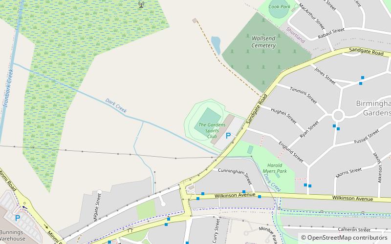
The Gardens Greyhound and Sporting Complex, Newcastle
Map
Facts and practical information
The Gardens Greyhound and Sporting Complex is an Australian stadium located in Newcastle, New South Wales. The complex is known as Newcastle Greyhounds when it was used as a greyhound racing venue. It was the former home of the Newcastle Breakers, who played in the National Soccer League from 1991 until 2000. It was also the home ground of the short-lived Hunter Mariners rugby league team, who participated in the only season of the Super League in 1997. The stadium is currently used by soccer team Wallsend FC. ()
Capacity: 4000Coordinates: 32°53'36"S, 151°40'55"E
Address
Sandgate RdNewcastle 2287
ContactAdd
Social media
Add
Getting there by public transportation
Public transportation stops near this location
- Bus
 Bus
Bus
- Calculate routeBlue Gum Rd Near Goodwin St 18 min walk
- Calculate routeNewcastle Rd Near Pumping Station 18 min walk
- Calculate routeUniversity Dr Near Blue Gum Rd 19 min walk
Day trips


Frequently Asked Questions (FAQ)
How to get to The Gardens Greyhound and Sporting Complex by public transport?
The nearest stations to The Gardens Greyhound and Sporting Complex:
Bus
Bus
- Blue Gum Rd Near Goodwin St • Lines: 11 (18 min walk)
- Newcastle Rd Near Pumping Station • Lines: 12 (18 min walk)