Geelong Greyhound Racing Club, Geelong
Map
Facts and practical information
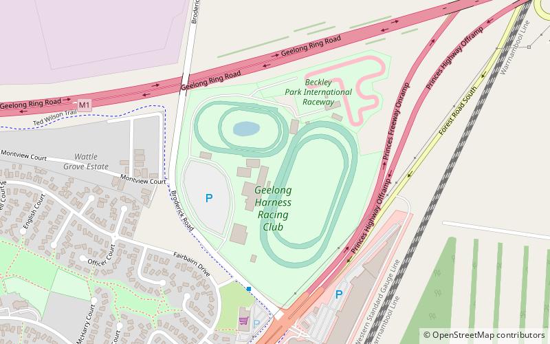
Geelong Greyhound Racing Club or The Beckley Centre is a greyhound racing venue located at Beckley Park, Broderick Road, Corio, Geelong, Victoria. The Beckley Centre is operated by the Geelong Greyhound Racing Club and regulated by Greyhound Racing Victoria. It hosts the Geelong Cup and has race distances over 400, 460, 520, 596 and 680 metres. Racing is conducted on Tuesday and Friday and occasional Saturdays. ()
Coordinates: 38°3'41"S, 144°22'52"E
Address
Geelong
ContactAdd
Social media
Add
Getting there by public transportation
Public transportation stops near this location
- Bus
- Train
 Bus
Bus
- Calculate routeSchool Rd/Princes Hwy 16 min walk
- Calculate routeSelma St/Princes Hwy 19 min walk
- Calculate routeCorio 20 min walk
Day trips


Frequently Asked Questions (FAQ)
How to get to Geelong Greyhound Racing Club by public transport?
The nearest stations to Geelong Greyhound Racing Club:
Bus
Train
Bus
- School Rd/Princes Hwy • Lines: 23 (16 min walk)
- Selma St/Princes Hwy • Lines: 23 (19 min walk)
Train
- Corio (20 min walk)