Planetshakers Church, Melbourne
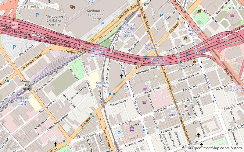
Map
Facts and practical information
Planetshakers Church is an evangelical Christian Pentecostal megachurch adult and youth movement based in Melbourne, Australia, with several church campuses around the world. ()
Address
400 City RoadCity of Melbourne (Southbank)Melbourne
ContactAdd
Social media
Add
Getting there by public transportation
Public transportation stops near this location
- Bus
- Tram
- Train
- Ferry
 Bus
Bus
- Calculate routeStop 126: City Road 5 min walk
- Calculate routeStop 125A: Southbank Tram Depot 4 min walk
- Calculate routeClarendon Street 3 min walk
- Calculate routeFerrars Street 5 min walk
- Calculate routeSouth Melbourne Market 6 min walk
- Calculate routeMontague Street/City Road 8 min walk
- Calculate routeSouthern Cross 20 min walk
- Calculate routeFlinders Street 26 min walk
- Calculate routePort Phillip Ferries 27 min walk
Maps Melbourne TramsMaps
 Victoria Trains
Melbourne TramsMapsVictoria TrainsDay trips


Frequently Asked Questions (FAQ)
Which popular attractions are close to Planetshakers Church?
Nearby attractions include South Melbourne Market, Melbourne (6 min walk), Montague Street Bridge, Melbourne (8 min walk), Melbourne Convention and Exhibition Centre, Melbourne (9 min walk), Polly Woodside, Melbourne (9 min walk).
How to get to Planetshakers Church by public transport?
The nearest stations to Planetshakers Church:
Tram
Bus
Train
Ferry
Tram
- Stop 126: City Road • Lines: 12, 12d, 96, 96d (5 min walk)
- Stop 125A: Southbank Tram Depot • Lines: 109, 109d, 12d, 96d (4 min walk)
Bus
- Clarendon Street • Lines: 234, 236 (3 min walk)
- Ferrars Street • Lines: 234 (5 min walk)
Train
- Southern Cross (20 min walk)
- Flinders Street (26 min walk)
Ferry
- Port Phillip Ferries (27 min walk)