North Quay, Brisbane
Map

Gallery

Facts and practical information
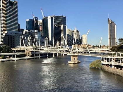
North Quay is a location in the Brisbane central business district and the name of street in the same area, running along the Brisbane River from an intersection near Makerston Street to the top of the Queen Street, linking the Victoria Bridge, and the William Jolly Bridge along the river’s northern bank. It was the site of Brisbane’s initial settlement, at a point where a stream flowing from Spring Hill provided fresh water, later collected in a reservoir on Tank Street. ()
Coordinates: 27°28'4"S, 153°1'1"E
Address
Brisbane CityBrisbane
ContactAdd
Social media
Add
Day trips
North Quay – popular in the area (distance from the attraction)
Nearby attractions include: Gallery of Modern Art, QAGOMA, Brisbane Arcade, Roma Street Parkland.
Frequently Asked Questions (FAQ)
Which popular attractions are close to North Quay?
Nearby attractions include William Jolly Bridge, Brisbane (3 min walk), Queensland Police Museum, Brisbane (3 min walk), Kurilpa Bridge, Brisbane (4 min walk), First Brisbane Burial Ground, Brisbane (4 min walk).
How to get to North Quay by public transport?
The nearest stations to North Quay:
Bus
Train
Ferry
Bus
- North Quay Stop 106 near Herschel St • Lines: 471 (3 min walk)
- Roma Street Stop 122 near Garrick St • Lines: 470, 475, 476 (3 min walk)
Train
- Roma Street (6 min walk)
- Central (15 min walk)
Ferry
- North Quay 1 • Lines: Chop-400, Uqsl-1410 (13 min walk)
- North Quay 2 • Lines: Chop-400 (13 min walk)


