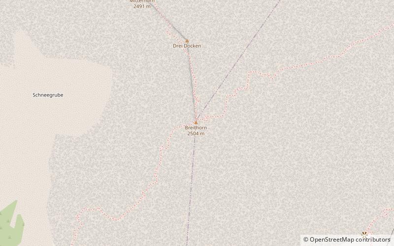
Breithorn
#632 among destinations in Austria

Facts and practical information
Breithorn is a summit in the Steinernes Meer of the Berchtesgaden Alps in the Austrian state of Salzburg. ()
SalzburgAustria
Breithorn plan & book
Unleash the traveler in you — discover the cheapest flight deals, find the perfect hotel or hostel nearby, and search for the best car rental prices. Travel at your own pace to discover new places and enjoy your journey.
Breithorn – popular in the area (distance from the attraction)
Nearby attractions include: Schönfeldspitze, Selbhorn, Persailhorn, Mitterhorn.
 Nature, Natural attraction, Mountain
Schönfeldspitze
42 min walk • Schönfeldspitze is, with an elevation of 2,653 m, the second highest mountain in the Steinernes Meer, a sub-range of the Berchtesgaden Alps. It is located in the Austrian state of Salzburg, close to the German border. Schönfeldspitze has a quite uncommon summit cross showing Virgin Mary cradling the dead body of Jesus.
 Nature, Natural attraction, Mountain
Selbhorn
76 min walk • Selbhorn is with an elevation of 2,655 m the highest mountain in the Steinernes Meer, a sub-range of the Berchtesgaden Alps. It is located in the Austrian state Salzburg, close to the German border.
 Nature, Natural attraction, Mountain
Persailhorn
15 min walk • Persailhorn is a summit in the Steinernes Meer of the Berchtesgaden Alps in the Austrian state of Salzburg.
 Nature, Natural attraction, Mountain
Mitterhorn
8 min walk • Mitterhorn is a summit in the Steinernes Meer of the Berchtesgaden Alps in the Austrian state of Salzburg.
 Nature, Natural attraction, Mountain
Seehorn
121 min walk • The Seehorn is a mountain, 2,321 m, in the Berchtesgaden Alps, in the Pinzgau region of Austria, not far from the border between the Austrian state of Salzburg and Bavaria in Germany.
 Nature, Natural attraction, Mountain
Wildalmkirchl
109 min walk • The Wildalmkirchl is a rocky peak, 2,578 m, on the southern edge of the Steinernes Meer. It lies within the Austrian state of Salzburg, northeast of the village of Maria Alm and northwest of the Hochkönig massif.
 Nature, Natural attraction, Mountain
Brandhorn
123 min walk • The Brandhorn is a mountain, 2,610 m, in the Berchtesgaden Alps in the Austrian state of Salzburg. It lies in the southeast of the Steinernes Meer, at the crossing to the Hochkönig.
 Forts and castles
Schloss Dorfheim, Saalfelden
92 min walk • Schloss Dorfheim is located on the western edge of Saalfelden on the road to Leogang. The building only still has the character of a castle on the outside with a high hipped roof and the two remaining corner towers facing south.
 Forts and castles
Schloss Lichtenberg
59 min walk • Schloss Lichtenberg, also Burg Lichtenberg, a former Pfleggericht, is a castle in Saalfelden, a municipality in the Austrian province of Salzburg.
 Locality
Maria Alm
96 min walk • Nestled in the breathtaking Salzburg region of Austria, Maria Alm is a charming alpine village that offers visitors a perfect blend of outdoor adventure and traditional Austrian culture. Surrounded by the majestic peaks of the Hochkönig mountain range, Maria Alm is a...
 Nature, Natural attraction, Mountain pass
Filzen Saddle
159 min walk • The Filzen Saddle is a mountain pass, 1,290 m above sea level high, between Saalfelden am Steinernen Meer near Hinterthal/Maria Alm in the Pinzgau region and Dienten am Hochkönig in the Pongau in the Austrian federal state of Salzburg.


