Simonyspitzen
#345 among destinations in Austria
![Simonyspitzen location map](https://tzmedia.b-cdn.net/media/images/static-maps/at/47_0728_12_2615.jpg)
Facts and practical information
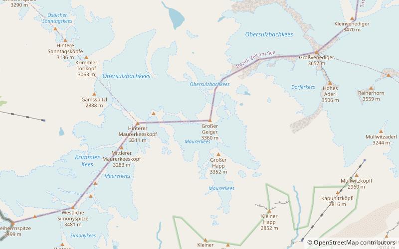
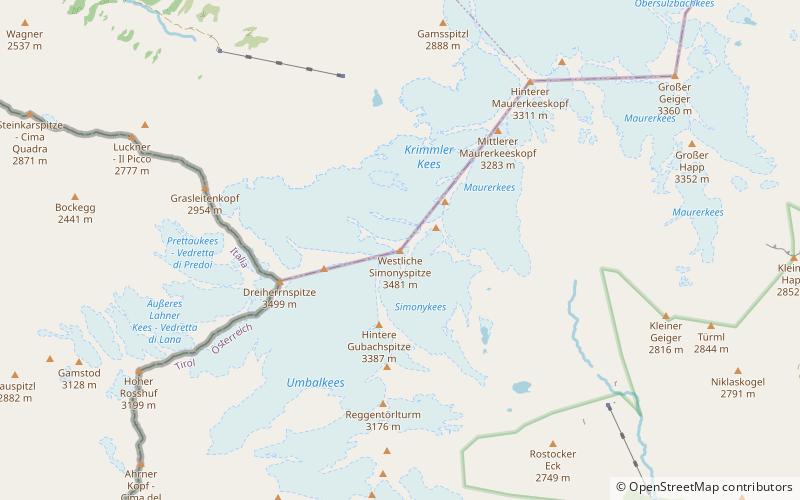
The Simonyspitzen are two mountain summits in the Venediger Group of the Austrian Central Alps. They lie within the High Tauern National Park on the border between the Austrian states of East Tyrol and Salzburg. ()
TyrolAustria
Simonyspitzen plan & book
Unleash the traveler in you — discover the cheapest flight deals, find the perfect hotel or hostel nearby, and search for the best car rental prices. Travel at your own pace to discover new places and enjoy your journey.
Simonyspitzen – popular in the area (distance from the attraction)
Nearby attractions include: Großvenediger, Schlatenkees, Rainerhorn, Großer Geiger.
4.7 miNENature, Natural attraction, MountainGroßvenediger
120 min walk • The Großvenediger, a majestic peak in the heart of the Hohe Tauern National Park in Austria, stands as an imposing figure on the alpine skyline. Towering at an impressive 3,666 meters (12,028 feet), it is the fifth highest mountain in Austria and one of the most...
5.8 miENatural featureSchlatenkees, National parks of Austria
148 min walk • The Schlatenkees is a glacier in the Venediger Group that is in the core zone of the High Tauern National Park, east of the Großvenediger. It is in the East Tyrolean community of Matrei in Osttirol.
5.2 miEMountainRainerhorn, National parks of Austria
133 min walk • The Rainerhorn is a mountain in the Venediger Group. It is 3,559 m high.
2.6 miNENature, Natural attraction, MountainGroßer Geiger
67 min walk • The Großer Geiger, formerly also called the Obersulzbacher Venediger and Heiliggeistkogel, is a mountain, 3,360 m, in the Venediger Group in the main chain of the Central Tauern.
2.4 miNENatural featureVenediger Group, National parks of Austria
63 min walk • The Venediger Group is a mountain range of the Central Eastern Alps. Together with the Granatspitze Group, the Glockner Group, the Goldberg Group, and the Ankogel Group, it forms the main ridge of the High Tauern.
3.8 miWMountainWestliches Zwillingsköpfl
97 min walk • The Westliches Zwillingsköpfl, is a 2,835-metre mountain peak on the border of Italy and Austria. The Westliches Zwillingsköpfl is the northernmost point of Italy, even though the nearby Glockenkarkopf is often considered to hold this distinction.
4.7 miSENature, Natural attraction, MountainRote Säule
121 min walk • The Rote Säule or Rote Saile is a mountain, 2,820 metres high on the Wallhornkamm in the Venediger Group. Its summit is accessible from Prägraten via the Sajat Hut and from there via an only slightly exposed normal route via the Saukopf or up a klettersteig with two climbing options.
1 miWNature, Natural attraction, MountainDreiherrnspitze
26 min walk • The Dreiherrnspitze, at 3,499 m above mean sea level, is a mountain on the tripoint between the Austrian states of Salzburg and Tyrol, and South Tyrol in Italy.
5 miNENature, Natural attraction, MountainKeeskogel
128 min walk • The Keeskogel, a mountain with a height of 3,291 m, lies in the Venediger Group of the High Tauern in Austria. The summit is located about 4 km as the crow flies northwest of the Großvenediger.
3.6 miNNature, Natural attraction, MountainSchlieferspitze
92 min walk • The Schlieferspitze is a mountain, 3,290 m, on the ridge known as the Krimmler Kamm in the Venediger Group of the Alps. The ridge lies in the northwest of the High Tauern, part of the Austrian Central Alps in the Austrian federal state of Salzburg.
4.1 miSWNature, Natural attraction, MountainRötspitze
106 min walk • The Rötspitze is a mountain in the Hohe Tauern on the border between Tyrol, Austria, and South Tyrol, Italy.