CeresByen, Aarhus
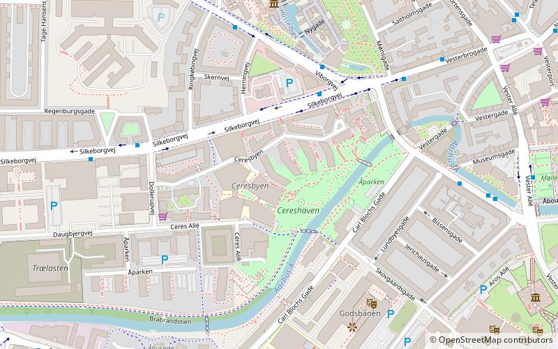
Map
Facts and practical information
CeresByen is a neighbourhood in Midtbyen, a district of the city of Aarhus, Denmark. It is a mixed residential and commercial area, comprising the site of the former Ceres Brewery operating here from 1856 until November 2008. The outer edges of CeresByen are defined by the streets Thorvaldsensgade, Silkeborgvej, Dollerupvej and Ceres Allé. ()
Area: 19.77 acres (0.0309 mi²)Coordinates: 56°9'22"N, 10°11'30"E
Address
Århus CAarhus
ContactAdd
Social media
Add
Getting there by public transportation
Public transportation stops near this location
- Bus
- Tram
- Light rail
- Train
 Bus
Bus
- Calculate routeCeresbyen 4 min walk
- Calculate routeAarhus Tech/Dollerupvej 6 min walk
- Calculate routeDen Gamle By 6 min walk
- Calculate routeVesterbrogade 6 min walk
- Calculate routeAarhus H 17 min walk
- Calculate routeNørreport 22 min walk
- Calculate routeAarhus Universitet/Nordre Ringgade 31 min walk
- Calculate routeAarhus Central Station 17 min walk
- Calculate routeSkolebakken 22 min walk
- Calculate routeØstbanetorvet 28 min walk
- Calculate routeSkolebakken 22 min walk
- Calculate routeDokk1 22 min walk
- Calculate routeNørreport 22 min walk
- Calculate routeUniversitetsparken 25 min walk
Day trips


Frequently Asked Questions (FAQ)
Which popular attractions are close to CeresByen?
Nearby attractions include Åparken, Aarhus (3 min walk), Danish Poster Museum, Aarhus (5 min walk), Godsbanen, Aarhus (5 min walk), The Old Town, Aarhus (6 min walk).
How to get to CeresByen by public transport?
The nearest stations to CeresByen:
Bus
Light rail
Train
Tram
Bus
- Ceresbyen • Lines: 11, 113, 3A, 4A (4 min walk)
- Aarhus Tech/Dollerupvej • Lines: 11, 113, 4A (6 min walk)
Light rail
- Aarhus H • Lines: L2 (17 min walk)
- Nørreport • Lines: L2 (22 min walk)
Train
- Aarhus Central Station (17 min walk)
- Skolebakken (22 min walk)
Tram
- Skolebakken • Lines: L2 (22 min walk)
- Dokk1 • Lines: L2 (22 min walk)