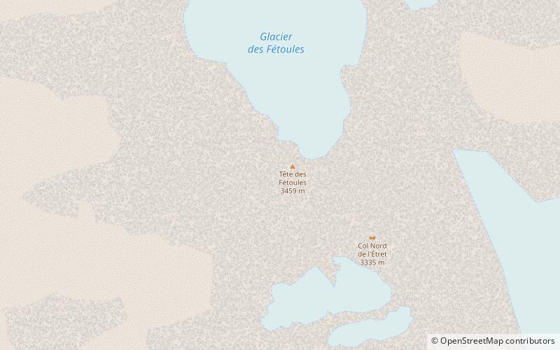
Tête des Fétoules, Écrins National Park
#35 among attractions in Écrins National Park

Facts and practical information
Tête des Fétoules is a mountain in the French Alps. Located in the Massif des Écrins, the mountain is 3,459 m tall. ()
Écrins National Park France
Écrins National Park plan & book
Unleash the traveler in you — discover the cheapest flight deals, find the perfect hotel or hostel nearby, and search for the best car rental prices. Travel at your own pace to discover new places and enjoy your journey.
Tête des Fétoules – popular in the area (distance from the attraction)
Nearby attractions include: Aiguille Dibona, Grande Ruine, Les Bans, Olan Mountain.
 Nature, Natural attraction, Mountain
Aiguille Dibona
113 min walk • The Aiguille Dibona, formerly called Pain de Sucre du Soreiller, is a mountain in the Massif des Écrins in the French Alps notable for its "astonishing triangular granite...
 Nature, Natural attraction, Mountain
Grande Ruine, Écrins National Park
167 min walk • La Grande Ruine is a mountain in Hautes-Alpes, France. It belongs to the Massif des Écrins in the Dauphiné Alps and is located in the heart of the wilderness of the Écrins National Park roughly halfway between its illustrious neighbours Barre des Écrins and Meije.
 Nature, Natural attraction, Mountain
Les Bans, Écrins National Park
151 min walk • Les Bans is a mountain in the Massif des Écrins in the Dauphiné Alps, first climbed by W. A. B. Coolidge, Christian Almer and U. Almer on July 14, 1878.
 Nature, Natural attraction, Mountain
Olan Mountain, Écrins National Park
88 min walk • The Olan is a mountain in the Massif des Écrins in the French Alps. It dominates the valleys of Valgaudemar, Valjouffrey, and Vénéon in the heart of Écrins National Park.
 Nature, Natural attraction, Mountain
Aiguille du Plat de la Selle
116 min walk • The Aiguille du Plat de la Selle, 3,596 m, is a mountain of the Massif des Écrins in the Dauphiné Alps in south-eastern France. Ascents of the mountain are via Saint-Christophe-en-Oisans or the Soreiller hut.
 Nature, Natural attraction, Mountain
Aiguille des Arias, Écrins National Park
79 min walk • Aiguille des Arias is a mountain of the French Alps in Isère. Located in the Massif des Écrins, the mountain is 3,403 m tall. The mirror of Fétoules is a lake that has reflection of Tête de Lauranoure to right Le Bec du Canard and the l'Aiguille des Arias in the center.
 Towering peak with expansive views
Barre des Écrins, Écrins National Park
125 min walk • The Barre des Écrins is a mountain in the French Alps with a peak elevation of 4,102 metres. It is the highest peak of the Massif des Écrins and the Dauphiné Alps and the most southerly alpine peak in Europe that is higher than 4,000 metres.
 Nature, Natural attraction, Mountain
Tête du Rouget
103 min walk • Tête du Rouget is a mountain in the French Alps, located in the Massif des Écrins. The mountain has a summit elevation of 3,418 m.
 Nature, Natural attraction, Mountain
Les Rouies, Écrins National Park
69 min walk • Les Rouies is a mountain in the French Alps. Located in the Massif des Écrins, the mountain is 3,589 m tall.
 Nature, Natural attraction, Natural feature
Dauphiné Alps, Écrins National Park
124 min walk • The Dauphiné Alps are a group of mountain ranges in southeastern France, west of the main chain of the Alps. Mountain ranges within the Dauphiné Alps include the Massif des Écrins, Belledonne, the Taillefer range and the mountains of Matheysine.
 Nature, Natural attraction, Mountain
Roche Méane, Écrins National Park
179 min walk • Roche Méane is a two-summit peak in the Massif des Écrins in the French Alps. It is located on the crest between Barre des Écrins and La Meije.


