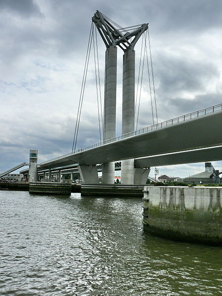
Pont Gustave-Flaubert, Rouen

Gallery (4)
Map

Map
Gallery
Facts and practical information
Alternative names: Opened: 25 September 2008 (17 years ago)Length: 2198 ftCoordinates: 49°26'29"N, 1°3'54"E
Address
Saint-Clément - Jardin des Plantes (Zone Portuaire Sud)Rouen
ContactAdd
Social media
Add
Getting there by public transportation
Public transportation stops near this location
- Bus
- Tram
 Bus
Bus
- Calculate routeLuciline 11 min walk
- Calculate routeMont-Riboudet Kindarena 14 min walk
- Calculate routePasteur-Panorama 14 min walk
- Calculate routeOrléans 17 min walk
- Calculate routeAvenue de Caen 24 min walk
- Calculate routeJean Jaurès 25 min walk
- Calculate routeSaint-Sever 26 min walk
- Calculate routeFrançois Truffaut 27 min walk
Day trips


Frequently Asked Questions (FAQ)
Which popular attractions are close to Pont Gustave-Flaubert?
Nearby attractions include Maritime, Rouen (8 min walk), Le 106, Rouen (12 min walk), Panorama XXL, Rouen (14 min walk), Pont Guillaume-le-Conquérant, Rouen (19 min walk).
How to get to Pont Gustave-Flaubert by public transport?
The nearest stations to Pont Gustave-Flaubert:
Bus
Tram
Bus
- Luciline • Lines: T1, T2, T3 (11 min walk)
- Mont-Riboudet Kindarena • Lines: 30, F4, T1, T2, T3 (14 min walk)
Tram
- Avenue de Caen • Lines: M (24 min walk)
- Jean Jaurès • Lines: M (25 min walk)