Kurohama Shell Mound, Shiraoka
#1 among attractions in Shiraoka
![Kurohama Shell Mound location map](https://tzmedia.b-cdn.net/media/images/static-maps/jp/35_99231_139_66235.jpg)
Facts and practical information
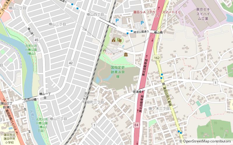
Shiraoka Japan
Shiraoka plan & book
Unleash the traveler in you — discover the cheapest flight deals, find the perfect hotel or hostel nearby, and search for the best car rental prices. Travel at your own pace to discover new places and enjoy your journey.
Kurohama Shell Mound – popular in the area (distance from the attraction)
Nearby attractions include: NACK5 Stadium Omiya, Tobu Zoo, Hikawa Shrine, Omiya Park.
5.5 miSSport venue, Sport, Arenas and stadiumsNACK5 Stadium Omiya, Saitama
140 min walk • NACK5 Stadium Omiya, also known as Omiya Park Soccer Stadium, is an emblematic sports venue nestled in the heart of Saitama, Japan. This purpose-built stadium specializes in hosting football matches and is the proud home ground of the J-League's Omiya Ardija football...
3.4 miNETheme park, Amusement park, ZooTobu Zoo, Kasukabe
88 min walk • Tobu Zoo is a combination of a zoo and an amusement park located in Miyashiro, Saitama Prefecture, Japan.
5.5 miSAncient Shinto shrine on scenic parklandHikawa Shrine, Saitama
141 min walk • Nestled in the bustling city of Saitama, Japan, Hikawa Shrine stands as a serene testament to the country's ancient Shinto traditions. This historic shrine, which is believed to have a history spanning over 2,000 years, serves as a spiritual center for the local...
5.4 miSLarge wooded park with cherry blossomsOmiya Park, Saitama
137 min walk • Omiya Park, a verdant oasis nestled in the heart of Saitama City, Japan, offers a serene escape from the urban bustle. This sprawling public space is renowned for its rich history, lush landscapes, and cultural significance, making it a favorite destination for both...
4.7 miSMuseum, Art museumŌmiya Bonsai Village, Saitama
120 min walk • Tucked away in the quiet city of Saitama, Japan, lies the serene and verdant Ōmiya Bonsai Village, a living museum dedicated to the ancient and meticulous art of bonsai. This tranquil enclave is home to a community of bonsai masters who have been nurturing miniature...
5.2 miSLocal art, history and folklore museumSaitama Prefectural Museum of History and Folklore, Saitama
134 min walk • Nestled in the heart of Saitama City lies a cultural gem: the Saitama Prefectural Museum of History and Folklore. This institution serves as a portal into the region's rich past, offering a window into the lives of the people who have shaped the area's history over the...
3.8 miSEForts and castlesIwatsuki Castle, Kasukabe
97 min walk • Iwatsuki Castle is a Japanese castle located in Iwatsuki-ku, Saitama, in Saitama Prefecture, Japan. At the end of the Edo period, Tateyama Castle was home to the Ōoka clan, daimyō of Iwatsuki Domain, however the castle dates from the Muromachi period and was inhabited by many samurai lords over its history.
5 miSWAreaAgeo, Saitama
128 min walk • Ageo is a city located in Saitama Prefecture, Japan. As of 1 January 2021, the city had an estimated population of 229,517 in 103,709 households and a population density of 5000 persons per km². The total area of the city is 45.51 square kilometres.
3.9 miNETown, AreaMiyashiro, Kasukabe
99 min walk • Miyashiro is a town located in Saitama Prefecture, Japan. As of 1 March 2021, the town had an estimated population of 33,823 in 15,234 households and a population density of 2100 persons per km². The total area of the town is 15.95 square kilometres.
4.7 miNETown, AreaSugito, Kasukabe
120 min walk • Sugito is a town located in Saitama Prefecture, Japan. As of 1 March 2021, the town had an estimated population of 44,402 in 19,409 households and a population density of 1500 persons per km². The total area of the town is 30.03 square kilometres.
2.1 miWTown, AreaIna, Saitama
54 min walk • Ina is a town in Saitama Prefecture, Japan. As of 1 March 2021, the town had an estimated population of 44,928 in 18,907 households and a population density of 3000 persons per km². The total area of the town is 30.03 square kilometres.