Victorino Mapa Street, Manila

Gallery (1)
Map
Map
Facts and practical information
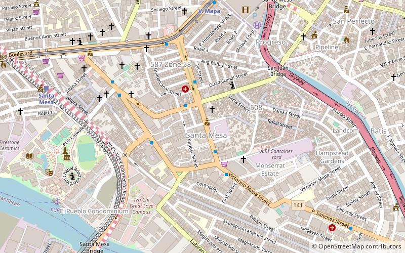
Victorino Mapa Street, also known by its short form V. Mapa Street, is the main north–south road in the district of Santa Mesa in Manila, Philippines. The street, including its eastern extension, runs for 1.6 kilometers from the junction with Magsaysay Boulevard in the north to Pat Antonio Street in the southeast by the San Juan River that serves as the district's border with San Juan and Mandaluyong. It is home to Don Bosco School, Manila, Unciano Colleges and General Hospital, and several new condominiums and a few motels. ()
Coordinates: 14°35'57"N, 121°1'1"E
Address
Santa MesaManila
ContactAdd
Social media
Add
Getting there by public transportation
Public transportation stops near this location
- Metro
- Bus
- Train
- Ferry
 Metro
Metro
- Calculate routeBacood 3 min walk
- Calculate routeOld Santa Mesa 4 min walk
- Calculate routePaco-Santa Mesa Road 4 min walk
- Calculate routeV. Mapa 7 min walk
- Calculate routeV. Mapa 9 min walk
- Calculate routePureza 21 min walk
- Calculate routeJ. Ruiz 26 min walk
- Calculate routeGilmore 39 min walk
- Calculate routeSanta Mesa 12 min walk
- Calculate routePandacan 21 min walk
- Calculate routePup 12 min walk
- Calculate routeLambingan 21 min walk
- Calculate routeSanta Ana 31 min walk
Day trips


Frequently Asked Questions (FAQ)
Which popular attractions are close to Victorino Mapa Street?
Nearby attractions include Santa Mesa, Manila (2 min walk), San Juan River Bridge, Manila (7 min walk), Mabini Shrine, Manila (11 min walk), Polytechnic University of the Philippines, Manila (11 min walk).
How to get to Victorino Mapa Street by public transport?
The nearest stations to Victorino Mapa Street:
Bus
Metro
Train
Ferry
Bus
- Bacood • Lines: 307, T393 (3 min walk)
- Old Santa Mesa • Lines: 306, 307, T393 (4 min walk)
Metro
- V. Mapa • Lines: 2 (9 min walk)
- Pureza • Lines: 2 (21 min walk)
Train
- Santa Mesa (12 min walk)
- Pandacan (21 min walk)
Ferry
- Pup • Lines: Pasig River Ferry (12 min walk)
- Lambingan • Lines: Pasig River Ferry (21 min walk)