Brunkebergsåsen, Stockholm

Map
Facts and practical information
Brunkebergsåsen was an esker that once reached over much of Stockholm's Norrmalm district. Geologically, it is a part of the much larger Stockholmsåsen. It formed a considerable obstacle to traffic, effectively dividing Norrmalm into a western and an eastern part. Consequently, most of it has been dug away over the centuries to make room for the development of that district. The pedestrian tunnel Brunkebergstunneln and, since the 1910s, the eastern part of Kungsgatan cut through Brunkebergsåsen's southern part. Conspicuous remnants of the esker can be seen in the vicinity of Johannes kyrka, at Observatorielunden, and Vanadislunden. ()
Address
Norrmalm (Södra Johannes)Stockholm
ContactAdd
Social media
Add
Getting there by public transportation
Public transportation stops near this location
- Metro
- Bus
- Tram
- Light rail
- Train
- Ferry
 Metro
Metro
- Calculate routeAdolf Fredrik Church 3 min walk
- Calculate routeTegnérgatan 4 min walk
- Calculate routeEriksbergsgatan 5 min walk
- Calculate routeRegeringsgatan 5 min walk
- Calculate routeHötorget 4 min walk
- Calculate routeRådmansgatan 7 min walk
- Calculate routeT-Centralen 11 min walk
- Calculate routeÖstermalmstorg 14 min walk
- Calculate routeT-Centralen 11 min walk
- Calculate routeKungsträdgården 11 min walk
- Calculate routeNybroplan 15 min walk
- Calculate routeStyrmansgatan 22 min walk
- Calculate routeStockholm City 12 min walk
- Calculate routeStockholms central 16 min walk
- Calculate routeStockholm Odenplan 20 min walk
- Calculate routeNybroplan 16 min walk
- Calculate routeNybrokajen 17 min walk
- Calculate routeStrömkajen 18 min walk
- Calculate routeStrandvägen 19 min walk
- Calculate routeStockholms östra 17 min walk
Maps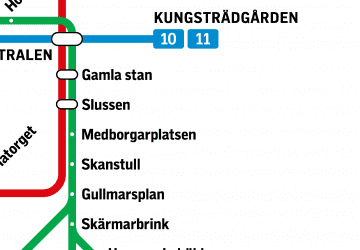 MetroMaps
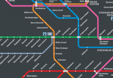 Rail network map
MetroMapsRail network mapDay trips


Frequently Asked Questions (FAQ)
Which popular attractions are close to Brunkebergsåsen?
Nearby attractions include Brunkeberg Tunnel, Stockholm (2 min walk), St. John's Church, Stockholm (3 min walk), Tunnelgatan, Stockholm (3 min walk), Sveavägen, Stockholm (4 min walk).
How to get to Brunkebergsåsen by public transport?
The nearest stations to Brunkebergsåsen:
Bus
Metro
Tram
Train
Ferry
Light rail
Bus
- Adolf Fredrik Church • Lines: 57 (3 min walk)
- Tegnérgatan • Lines: 57 (4 min walk)
Metro
- Hötorget • Lines: 17, 18, 19 (4 min walk)
- Rådmansgatan • Lines: 17, 18, 19 (7 min walk)
Tram
- T-Centralen • Lines: 7 (11 min walk)
- Kungsträdgården • Lines: 7 (11 min walk)
Train
- Stockholm City (12 min walk)
- Stockholms central (16 min walk)
Ferry
- Nybroplan • Lines: 80, Royal Canal Tour (16 min walk)
- Nybrokajen • Lines: Grand Canal Cruise, Strömma Canal Tour (17 min walk)
Light rail
- Stockholms östra • Lines: 27, 28, 29 (17 min walk)