Royal Stables, Stockholm

Gallery (1)
Map

Map
Facts and practical information
The Royal Stables is the mews of the Swedish Monarchy which provides both the ceremonial transport for the Swedish Royal Family during state events and festive occasions and their everyday transportation capacity. The Royal Stables date from 1535, and were originally built on Helgeandsholmen, close to Stockholm Palace. The Royal Stables are today located just behind Strandvägen in Östermalm in central Stockholm, Sweden. The head of the Royal Stables is the Crown Equerry. ()
Address
Östermalm (Hedvig Eleonora)Stockholm
ContactAdd
Social media
Add
Getting there by public transportation
Public transportation stops near this location
- Metro
- Bus
- Tram
- Light rail
- Train
- Ferry
 Metro
Metro
- Calculate routeNybroplan 2 min walk
- Calculate routeNorrmalmstorg 6 min walk
- Calculate routeStyrmansgatan 6 min walk
- Calculate routeÖstermalmstorg 7 min walk
- Calculate routeNybroplan 2 min walk
- Calculate routeStyrmansgatan 6 min walk
- Calculate routeKungsträdgården 8 min walk
- Calculate routeDjurgårdsbron 13 min walk
- Calculate routeNybroplan 3 min walk
- Calculate routeStrandvägen 3 min walk
- Calculate routeNybrokajen 4 min walk
- Calculate routeStrömkajen 8 min walk
- Calculate routeÖstermalmstorg 5 min walk
- Calculate routeKungsträdgården 8 min walk
- Calculate routeHötorget 15 min walk
- Calculate routeT-Centralen 17 min walk
- Calculate routeStockholm City 18 min walk
- Calculate routeStockholms central 21 min walk
- Calculate routeStockholm Odenplan 36 min walk
- Calculate routeStockholms östra 26 min walk
Maps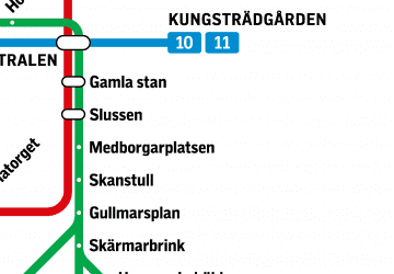 MetroMaps
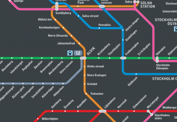 Rail network map
MetroMapsRail network mapDay trips
Royal Stables – popular in the area (distance from the attraction)
Nearby attractions include: Biblioteksgatan, Sturecompagniet, Nationalmuseum, Kungsträdgården.


Frequently Asked Questions (FAQ)
Which popular attractions are close to Royal Stables?
Nearby attractions include Artillerigatan, Stockholm (2 min walk), Stockholm Music Museum, Stockholm (2 min walk), Swedish Museum of Performing Arts, Stockholm (2 min walk), Royal Dramatic Theatre, Stockholm (2 min walk).
How to get to Royal Stables by public transport?
The nearest stations to Royal Stables:
Bus
Tram
Ferry
Metro
Train
Light rail
Bus
- Nybroplan • Lines: 54, 69, 76 (2 min walk)
- Norrmalmstorg • Lines: 2, 96 (6 min walk)
Tram
- Nybroplan • Lines: 7 (2 min walk)
- Styrmansgatan • Lines: 7 (6 min walk)
Ferry
- Nybroplan • Lines: 80, Royal Canal Tour (3 min walk)
- Strandvägen • Lines: Cinderella Stockholm ↔ Sandhamn (3 min walk)
Metro
- Östermalmstorg • Lines: 13, 14 (5 min walk)
- Kungsträdgården • Lines: 10, 11 (8 min walk)
Train
- Stockholm City (18 min walk)
- Stockholms central (21 min walk)
Light rail
- Stockholms östra • Lines: 27, 28, 29 (26 min walk)