Le Rubli
#923 among destinations in Switzerland
Facts and practical information
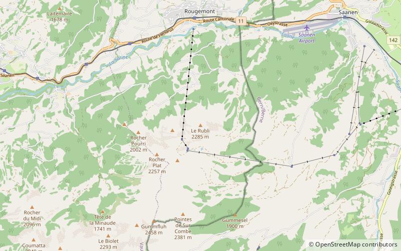
Le Rubli is a 2,285 metre high mountain in the western Bernese Alps, overlooking Rougemont in the canton of Vaud, near the border with the canton of Berne. Le Rubli has steep faces and its summit is relatively difficult to access. A via ferrata starts near the gondola station of the Videmanette. ()
VaudSwitzerland
Le Rubli plan & book
Unleash the traveler in you — discover the cheapest flight deals, find the perfect hotel or hostel nearby, and search for the best car rental prices. Travel at your own pace to discover new places and enjoy your journey.
Le Rubli – popular in the area (distance from the attraction)
Nearby attractions include: Roy Emerson Arena, Lac Lioson, Vanil Noir, Arnensee.
- 3.6 miESport venue, Sport
Roy Emerson Arena, Gstaad
93 min walk • Roy Emerson Arena is a tennis stadium located in Gstaad, Switzerland. The stadium is the centerpiece of the Suisse Open Gstaad, an ATP Tour event. The stadium has a capacity of 4,500 spectators.
- 6.6 miSWNature, Natural attraction, Lake
Lac Lioson, Les Diablerets
168 min walk • Lac Lioson is a lake in the municipality of Ormont-Dessous, near Les Mosses, in the canton of Vaud, Switzerland. Its surface area is 7 ha. The lake is used for fishing and ice diving.
- 5.4 miNWNature, Natural attraction, Mountain
Vanil Noir
138 min walk • The Vanil Noir is a mountain of the Fribourg Prealps, located on the border between the cantons of Fribourg and Vaud in western Switzerland.
- 5.1 miSNature, Natural attraction, Lake
Arnensee
131 min walk • Arnensee is a lake in Canton of Berne, Switzerland. The lake in the municipality of Gsteig is used as a reservoir by Romande Energie. The dam was built in 1942. Its volume is 10.5 mio m³ and surface area 0.456 km².
- 3 miSWNature, Natural attraction, Mountain
Rocher du Midi
78 min walk • The Rocher du Midi is a mountain in the western Bernese Alps, overlooking Château d'Oex in the canton of Vaud. It is located on the massif between the valley of the Sarine and L'Etivaz and culminating at the Gummfluh.
- 5.7 miNWNature, Natural attraction, Mountain
Vanil de l'Ecri
145 min walk • The Vanil de l'Ecri is a mountain of the Swiss Prealps, located on the border between the cantons of Fribourg and Vaud. Reaching a height of 2,376 metres above sea level, it is both the second highest summit of the Vanil Noir massif and the canton of Fribourg. The mountain lies between the Pointe de Paray and the Vanil Noir.
- 4.9 miNWNature, Natural attraction, Mountain
Pointe de Paray
126 min walk • The Pointe de Paray is a mountain of the Swiss Prealps, located on the border between the cantons of Fribourg and Vaud. It has a height of 2,375 metres above sea level, making it both the third highest summit of the Vanil Noir massif and the canton of Fribourg.
- 1.7 miSWNature, Natural attraction, Mountain
Gummfluh
45 min walk • The Gummfluh is a mountain in the western Bernese Alps, located on the border between the Swiss cantons of Vaud and Berne. It is the highest peak in the chain of mountains on the south side of the Pays d'Enhaut and it lies approximately halfway between Château d'Oex and Gstaad.
- 5 miNWNature, Natural attraction, Mountain
Vanil Carré
128 min walk • The Vanil Carré is a mountain in the western Bernese Alps, located on the border between the cantons of Fribourg and Vaud. It lies on the massif separating the valleys of Gruyère and Pays d'Enhaut, which culminates at the Vanil Noir.
- 6.3 miSWNature, Natural attraction, Mountain
Le Tarent, Les Diablerets
162 min walk • Le Tarent is a mountain in the western Bernese Alps, overlooking Les Diablerets in the canton of Vaud. At 2,548 metres above sea level, it is the highest mountain of the range lying north of the Col du Pillon.
- 4.3 miSENature, Natural attraction, Mountain
Höhi Wispile, Gstaad
110 min walk • The Höhi Wispile is a mountain of the Bernese Alps, overlooking Gstaad in the canton of Bern. It lies on the range separating the main Saane valley from the Lauenen valley, north of the Spitzhorn.