Tournelon Blanc
#1400 among destinations in Switzerland
![Tournelon Blanc location map](https://tzmedia.b-cdn.net/media/images/static-maps/ch/45_9697_7_32181.jpg)
Facts and practical information
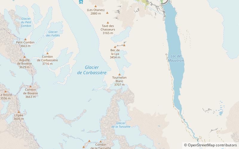
The Tournelon Blanc is a mountain of the Swiss Pennine Alps, overlooking the lake of Mauvoisin in the canton of Valais. It belongs to the Grand Combin massif and lies east of the Corbassière Glacier. ()
ValaisSwitzerland
Tournelon Blanc plan & book
Unleash the traveler in you — discover the cheapest flight deals, find the perfect hotel or hostel nearby, and search for the best car rental prices. Travel at your own pace to discover new places and enjoy your journey.
Tournelon Blanc – popular in the area (distance from the attraction)
Nearby attractions include: Grand Combin, Chanrion Hut, Mont Blanc de Cheilon, Aiguille du Croissant.
2.5 miSWNature, Natural attraction, MountainGrand Combin
63 min walk • The Grand Combin is a mountain massif in the western Pennine Alps in the canton of Valais. At a height of 4,314 metres the summit of Combin de Grafeneire is one of the highest peaks in the Alps and the second most prominent of the Pennine Alps.
3.5 miSEAlpine hut, HikingChanrion Hut
91 min walk • The Chanrion Hut French: is a mountain hut located in the upper Val de Bagnes in the canton of Valais in Switzerland. It lies in an isolated area south of Lac de Mauvoisin at an altitude of 2,462 metres, at the foot of Pointe d'Otemma. The easiest access is from the north.
4.9 miENature, Natural attraction, MountainMont Blanc de Cheilon
125 min walk • Mont Blanc de Cheilon is a mountain of the Pennine Alps, located in the Swiss canton of Valais. The mountain lies between the valleys of Bagnes and Arolla.
2.2 miSWNature, Natural attraction, MountainAiguille du Croissant
57 min walk • The Aiguille du Croissant is a minor summit in the Grand Combin massif in the Pennine Alps, Switzerland. Because of its small prominence it was included in the enlarged list of alpine four-thousanders.
2.7 miSWNature, Natural attraction, MountainCombin de Valsorey
68 min walk • The Combin de Valsorey is the second highest summit in the Grand Combin massif.
3.6 miSWAlpine hut, HikingValsorey Hut
93 min walk • The Valsorey Hut is a mountain hut of the Swiss Alpine Club, located south of Bourg-Saint-Pierre in the canton of Valais. The hut lies at a height of 3,030 metres above sea level, on the southwestern slopes of the Grand Combin in the Pennine Alps, facing Mont Vélan.
3.8 miENature, Natural attraction, MountainLa Ruinette
98 min walk • La Ruinette is a mountain of the Swiss Pennine Alps, overlooking the Lake of Mauvoisin in the canton of Valais. With an altitude of 3,875 metres above sea level, it is the highest summit between the Grand Combin and the Dent Blanche.
4.2 miNENature, Natural attraction, MountainLa Luette
108 min walk • La Luette is a mountain of the Pennine Alps, located between the valleys of Bagnes and Hérens in the canton of Valais. It lies just south of Le Pleureur.
1.6 miENature, Natural attraction, LakeLac de Mauvoisin
42 min walk • Lac de Mauvoisin is a reservoir in the canton of Valais, Switzerland. The reservoir is formed by the Mauvoisin Dam, which is 250 metres high. The dam is currently the 11th highest in the world, and the 6th highest arch dam. It was built in 1951–1957, and raised by 13.5 metres in 1991.
5.2 miNWNature, Natural attraction, MountainMont Rogneux
132 min walk • Mont Rogneux is a mountain of the Swiss Pennine Alps, overlooking Liddes in the canton of Valais. It is a mountain located north of the Petit Combin and Grand Combin. Facing the Verbier ski resort and neighbouring the Bruson lifts.
1.7 miNNature, Natural attraction, MountainGrand Tavé
45 min walk • The Grand Tavé is a mountain of the Swiss Pennine Alps, located south of Fionnay in the canton of Valais. It belongs to the Grand Combin massif and lies east of the Corbassière Glacier.