Cima Rossa
#853 among destinations in Switzerland
![Cima Rossa location map](https://tzmedia.b-cdn.net/media/images/static-maps/ch/46_4437_9_08663.jpg)
Facts and practical information
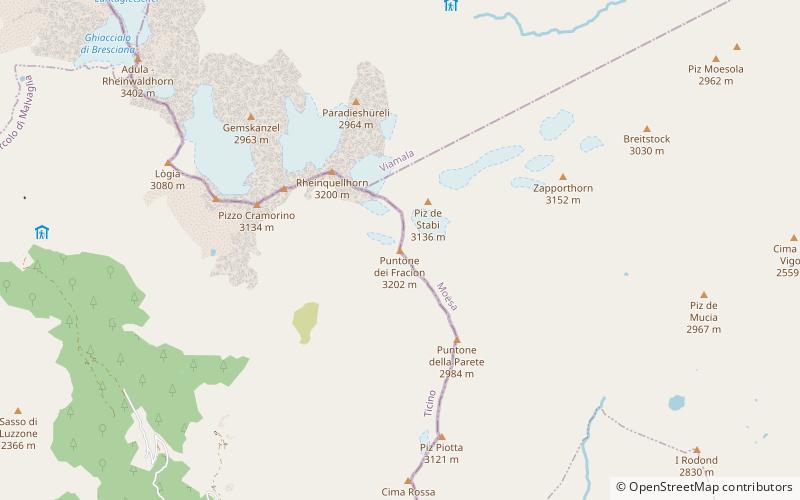
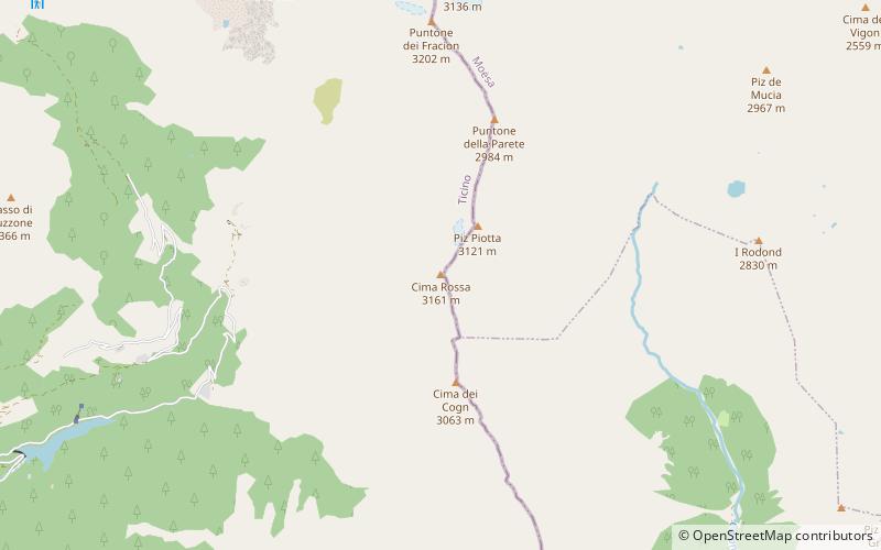
Cima Rossa is a 3,161 metres high mountain in the Lepontine Alps, located on the border between the cantons of Ticino and Graubünden. On the west side it overlooks the valley of Malvaglia and on the east side it overlooks the valley of Calanca. ()
TicinoSwitzerland
Cima Rossa plan & book
Unleash the traveler in you — discover the cheapest flight deals, find the perfect hotel or hostel nearby, and search for the best car rental prices. Travel at your own pace to discover new places and enjoy your journey.
Cima Rossa – popular in the area (distance from the attraction)
Nearby attractions include: Rheinwaldhorn, Lago d'Isola, Vogelberg, I Rodond.
4.1 miNWRidged alp summit first climbed in 1789Rheinwaldhorn
105 min walk • The Rheinwaldhorn is the highest point in the Swiss canton of Ticino at 3,402 metres above sea level. It lies on the border between the cantons of Graubünden and Ticino, in the Adula massif, part of the St.
4.9 miENature, Natural attraction, LakeLago d'Isola
125 min walk • Lago d'Isola is a reservoir at San Bernardino, Grisons, Switzerland. The reservoir's surface area is 39 ha.
2.6 miNWNature, Natural attraction, MountainVogelberg
67 min walk • The Vogelberg is a 3,218 metres high mountain of the Lepontine Alps, located on the border between the Swiss cantons of Ticino and Graubünden. It is the highest summit of the Lepontine Alps south of the Rheinwaldhorn.
2.4 miENature, Natural attraction, MountainI Rodond
61 min walk • I Rodond is a mountain of the Swiss Lepontine Alps, located west of San Bernardino in the canton of Graubünden. It lies north of the Pass di Passit, on the range between Val Calanca and Val Mesolcina.
4.9 miWNature, Natural attraction, MountainCima di Gana Bianca
125 min walk • The Cima di Gana Bianca is a mountain of the Swiss Lepontine Alps, overlooking Acquarossa in the canton of Ticino. It lies west of the Rheinwaldhorn, between the main Blenio valley and the Val Malvaglia.
1.9 miNNature, Natural attraction, MountainPuntone dei Fraciòn
49 min walk • Puntone dei Fraciòn is a 3,202-metre-high mountain in the Lepontine Alps, located on the border between the Swiss cantons of Ticino and Graubünden. It is the highest peak of the Calanca valley. On its west side it overlooks the valley of Malvaglia. It lies approximately halfway between the Vogelberg and the Zapporthorn.
4.9 miNNature, Natural attraction, MountainGüferhorn
125 min walk • The Güferhorn is a mountain in the Lepontine Alps, located between the valleys of Vals and Hinterrhein in Graubünden. At 3,379 metres above sea level it is the highest summit of the Lepontine Alps lying east of the Rheinwaldhorn.
3.8 miSNature, Natural attraction, MountainPiz di Strega
97 min walk • Piz di Strega is a mountain in the Lepontine Alps, overlooking Pass Giümela on the border between the cantons of Ticino and Graubünden. Its summit lies south of Pizzo di Ramulazz.
3.4 miSWNature, Natural attraction, LakeBacino di Val Malvaglia
86 min walk • Bacino di Val Malvaglia is a lake above Malvaglia in the canton of Ticino, Switzerland. The reservoir's surface area is 0.19 km². Its arch dam was built in 1959 and is operated by Officine Idroelettriche di Blenio SA.
2.8 miNENature, Natural attraction, MountainZapporthorn
71 min walk • The Zapporthorn or Pizzo Zapport is a mountain of the Swiss Lepontine Alps, overlooking San Bernardino Pass in Graubünden. Its summit is the tripoint between the valleys of Hinterrhein, Calanca and Mesolcina.
0.8 miSNature, Natural attraction, MountainCima dei Cogn
21 min walk • Cima dei Cogn is a mountain in the Lepontine Alps, located on the border between the cantons of Ticino and Graubünden. It lies south of the higher Cima Rossa.