Hohgant
#1670 among destinations in Switzerland
![Hohgant location map](https://tzmedia.b-cdn.net/media/images/static-maps/ch/46_7882_7_90183.jpg)
Facts and practical information
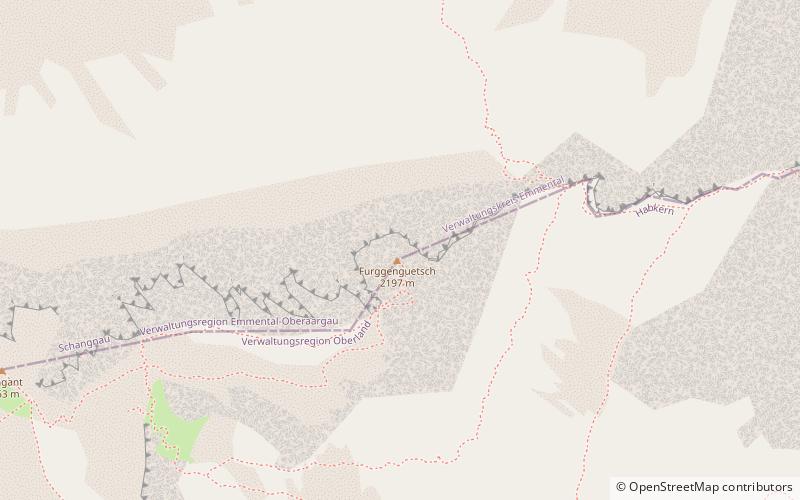
The Hohgant is a mountain of the Emmental Alps, located south of the Emmental in the canton of Berne. The main summit has an elevation of 2,197 metres above sea level and is distinguished by the name Furggengütsch. ()
BernSwitzerland
Hohgant plan & book
Unleash the traveler in you — discover the cheapest flight deals, find the perfect hotel or hostel nearby, and search for the best car rental prices. Travel at your own pace to discover new places and enjoy your journey.
Hohgant – popular in the area (distance from the attraction)
Nearby attractions include: Lake Brienz, Augstmatthorn, Sieben Hengste, Burgfeldstand.
5.4 miSETurquoise lake with walks and cruisesLake Brienz
139 min walk • Nestled in the heart of Switzerland, Lake Brienz is a pristine jewel of natural beauty that beckons travelers with its serene blue waters and breathtaking alpine backdrop. The lake, known in German as Brienzersee, stretches over an impressive 14 kilometers in length...
3.4 miSNature, Natural attraction, MountainAugstmatthorn
88 min walk • The Augstmatthorn is a mountain of the Emmental Alps, overlooking Lake Brienz in the Bernese Oberland. The largely forested land from the top of the mountain southwards to the lake has been identified by BirdLife International as a 15,900 ha Important Bird Area.
4.4 miSWNature, Natural attraction, MountainSieben Hengste
114 min walk • The Sieben Hengste is a mountain of the Emmental Alps, located north of Habkern, in the canton of Bern. It is composed of several summits of which the highest is named Chibe.
6.8 miSWNature, Natural attraction, MountainBurgfeldstand
174 min walk • The Burgfeldstand is a mountain of the Emmental Alps, located in the Bernese Oberland near Beatenberg. It is the highest summit of the Güggisgrat. Several trails lead to the top.
4.1 miNENature, Natural attraction, MountainSchrattenfluh, Entlebuch Biosphere
106 min walk • The Schrattenfluh is a mountain of the Swiss Alps, located in the upper Emmental, in the canton of Lucerne. The Schrattenfluh is composed of several summits of which the highest is named Hengst.
5.9 miSWNature, Natural attraction, MountainGemmenalphorn
152 min walk • The Gemmenalphorn is a mountain in the Emmental Alps. It lies north-east of Niederhorn, near...
4 miENature, Natural attraction, MountainTannhorn
103 min walk • The Tannhorn is a mountain of the Emmental Alps in Switzerland. It lies to the west of the Brienzer Rothorn and to the east of the Augstmatthorn. On its southern side it overlooks Lake Brienz.
4.3 miNNature, Natural attraction, MountainWachthubel
111 min walk • The Wachthubel is a mountain of the Emmental Alps, located on the border between the Swiss cantons of Bern and Lucerne. The mountain is located between Schangnau and Marbach.
5.6 miNWNature, Natural attraction, Mountain passSchallenberg Pass
143 min walk • Schallenberg Pass is a high mountain pass in the canton of Berne in Switzerland. It connects Steffisburg and Marbach. The pass road has a maximum grade of 10 percent.
6.1 miSEVillageIseltwald
156 min walk • Iseltwald is a village and municipality on the southern shore of Lake Brienz in the Bernese Oberland region of Switzerland. Politically, the municipality is located in the Interlaken-Oberhasli administrative district of the canton of Bern.
4.7 miWNature, Natural attraction, MountainHonegg
121 min walk • The Honegg is a mountain of the Emmental Alps, located between Schangnau and Eriz in the canton of Bern.