Hangendgletscherhorn
#1366 among destinations in Switzerland


Facts and practical information
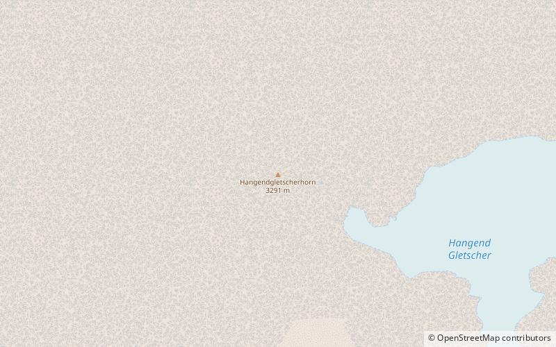
The Hangendgletscherhorn is a mountain of the Bernese Alps, located in the Urbachtal in the canton of Bern. On its northern side it overlooks the Gauli Glacier. ()
BernSwitzerland
Hangendgletscherhorn – popular in the area (distance from the attraction)
Nearby attractions include: Wetterhorn, Rosenhorn, Mittelhorn, Ritzlihorn.
3.3 miW
Nature, Natural attraction, MountainWetterhorn, Grindelwald
84 min walk • The Wetterhorn is a peak in the Swiss Alps towering above the village of Grindelwald. Formerly known as Hasle Jungfrau, it is one of three summits on a mountain named the "Wetterhörner", the highest of which is the Mittelhorn and the lowest and most distant the Rosenhorn.
2.2 miW
Nature, Natural attraction, MountainRosenhorn
55 min walk • The Rosenhorn is a peak in the Bernese Alps in the Bernese Oberland. It is lowest of the three composing the Wetterhorner massif, and most distant from the alpine village of Grindelwald to the southwest.
2.8 miW
Nature, Natural attraction, MountainMittelhorn
71 min walk • The Mittelhorn is a peak in the Swiss Alps close to the village of Grindelwald. It is the highest of the three composing the Wetterhorner massif.
3.6 miE
Nature, Natural attraction, MountainRitzlihorn
93 min walk • The Ritzlihorn is a mountain of the Bernese Alps, overlooking Handegg in the canton of Bern. It lies on the range east of the Gauli Glacier and north of the Bächlistock.
1.9 miN
Alpine hut, HikingDossen Hut
48 min walk • The Dossen Hut is a mountain hut of the Swiss Alpine Club, located south of Meiringen in the canton of Bern, Switzerland. It lies at a height of 2,663 metres above sea level, on the watershed between the Reichenbachtal and the Urbachtal, north of the Dossen.
1.6 miNW
Nature, Natural attraction, MountainDossen
42 min walk • The Dossen is a mountain in the Bernese Alps, overlooking Rosenlaui in the Bernese Oberland. It is located east of the Rosenlaui Glacier. The Dossen is composed of two summits: the northern summit and southern summit.
3.8 miNW
Nature, Natural attraction, ValleyReichenbachtal
98 min walk • Reichenbachtal is an Alpine valley in Oberhasli, canton of Berne, Switzerland. It is situated within the municipality of Schattenhalb, connecting Meiringen with the Grosse Scheidegg pass towards Grindelwald. Its water, the Rychenbach, forms the Reichenbach Fall before joining the Aare at Meiringen.
3.5 miE
Nature, Natural attraction, MountainSteinlauihorn
90 min walk • The Steinlauihorn is a mountain of the Bernese Alps, overlooking Handegg in the Bernese Oberland. It lies south of the Ritzlihorn, on the range separating the valley of the Gauli Glacier from the main Aar valley.
1.3 miSW
Nature, Natural attraction, Natural featureGauli Glacier
33 min walk • The Gauli Glacier is a 6.2 km long glacier in the Bernese Alps in the canton of Bern in Switzerland. In 1973, it had an area of 17.7 km².
2.4 miE
Nature, Natural attraction, LakeMattenalpsee
63 min walk • Mattenalpsee is a reservoir in the municipality of Innertkirchen, Canton of Berne, Switzerland. Its surface area is 18.6 ha. The reservoir receives the water from Gauli Glacier. The water is channeled into Räterichsbodensee.
3.9 miSE
Nature, Natural attraction, MountainGrosser Diamantstock
99 min walk • The Grosser Diamantstock is a mountain of the Bernese Alps, located west of Handegg in the Bernese Oberland. Its summit has an elevation of 3,162 metres above sea level and is the tripoint between the glacier valleys of Hiendertelltigletscher, Bächligletscher and Gruebengletscher.
