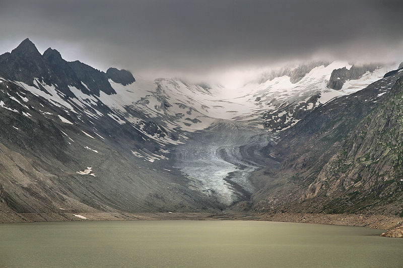
Oberaargletscher
#1748 among destinations in Switzerland


Facts and practical information
The Oberaargletscher, literally "Upper Aare-Glacier" is a 4 km long glacier situated in the Bernese Alps in the canton of Berne in Switzerland. In 1973 it had an area of 5.82 km2. The lower end of this glacier lies almost 400 m higher than the lower end of neighbouring Unteraargletscher. ()
BernSwitzerland
Oberaargletscher – popular in the area (distance from the attraction)
Nearby attractions include: Finsteraarhorn, Finsteraarrothorn, Oberaarhorn, Oberaarsee.
4 miWNature, Natural attraction, MountainFinsteraarhorn
103 min walk • Rising majestically above the Swiss Alps, the Finsteraarhorn stands as the highest peak in the Bernese Alps and an emblematic natural wonder of Switzerland. This towering mountain reaches an impressive altitude of 4,274 meters, making it the third highest mountain in...
3.1 miWMountainFinsteraarrothorn, Swiss Alps Jungfrau-Aletsch
80 min walk • The Finsteraarrothorn is a mountains of the Bernese Alps, overlooking the Fiescher Glacier in the canton of Valais. It lies at the southeastern end of the ridge descending from the Finsteraarhorn, between the Fiescher Glacier and the Studer Glacier.
1.7 miWNature, Natural attraction, MountainOberaarhorn
44 min walk • The Oberaarhorn is a mountain of the Bernese Alps, located on the border between the Swiss cantons of Valais and Bern. Its summit is the tripoint between the basins of the Fiesch, Unteraar and Oberaar Glacier.
2.3 miENature, Natural attraction, LakeOberaarsee
60 min walk • Oberaarsee is a hydroelectric reservoir in the Grimsel area, part of the municipality of Guttannen, Switzerland. Its surface area is 1.47 km². The Oberaar dam was completed in 1953, and is operated by Kraftwerke Oberhasli. It is drained by the Oberaarbach, which flows into the Grimselsee. The Oberaar glacier is located west of the lake.
2.6 miNAlpine hut, HikingLauteraar Hut
67 min walk • The Lauteraar Hut is a mountain hut of the Swiss Alpine Club, located south-west of Handegg in the canton of Bern. The hut lies at a height of 2,392 metres above sea level, above the Unteraar Glacier, at the foot of the Hienderstock in the Bernese Alps.
3.9 miSWNatural featureFiescher Glacier, Swiss Alps Jungfrau-Aletsch
99 min walk • The Fiescher Glacier is a valley glacier on the south side of the Bernese Alps in the canton of Valais, Switzerland. 16 km in length, it is the second longest glacier in the Alps. The glacier covers an area of 33 km².
2.3 miSWNature, Natural attraction, MountainGalmihorn
60 min walk • The Galmihorn is a mountain of the Bernese Alps, overlooking the Fiescher Glacier in the canton of Valais. The main summit is distinguished by the name Vorderes Galmihorn and has an elevation of 3,506 metres.
2.3 miNNature, Natural attraction, Natural featureUnteraargletscher
60 min walk • The Unteraargletscher, literally "Lower Aare-Glacier", is the larger of the two sources of the Aare river in the Bernese Alps. It emerges from the association of the Finsteraargletscher and the Lauteraargletscher and flows for about 6 km to the east down to the Grimselsee near the Grimsel Pass.
3.7 miNNature, Natural attraction, MountainHienderstock
95 min walk • The Hienderstock is a mountain in the Bernese Alps, located between the Gauli Glacier and the Unteraar Glacier, in the canton of Bern. Its main summit has an elevation of 3,307 metres above sea level.
1.6 miSWMountainOberaarrothorn, Swiss Alps Jungfrau-Aletsch
42 min walk • The Oberaarrothorn is a mountain of the Bernese Alps, on the border between the Swiss cantons of Valais and Bern. It is south of the Oberaarjoch, between the Fiescher Glacier and the Oberaar Glacier.
3.9 miNNature, Natural attraction, MountainBächlistock
101 min walk • The Bächlistock is a mountain of the Bernese Alps, overlooking the Unteraar Glacier in the canton of Bern. Its summit has an elevation of 3,247 metres above sea level and is the tripoint between the glacier valleys of Hiendertelltigletscher, Bächligletscher and Unteraar.