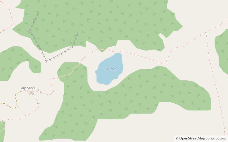
Alplersee
#873 among destinations in Switzerland

Facts and practical information
Alplersee is a lake on the slopes of the Rophaien mountain near Riemenstalden and Sisikon in the Canton of Uri, Switzerland. ()
UriSwitzerland
Alplersee plan & book
Unleash the traveler in you — discover the cheapest flight deals, find the perfect hotel or hostel nearby, and search for the best car rental prices. Travel at your own pace to discover new places and enjoy your journey.
Alplersee – popular in the area (distance from the attraction)
Nearby attractions include: Rütli, Tellskapelle, Tell Monument, Rudenz Castle.
 Historical place, Memorial
Rütli, Seelisberg
96 min walk • Rütli or Grütli is a mountain meadow on Lake Lucerne, in the Seelisberg municipality of the Swiss canton of Uri. It is the site of the Rütlischwur in traditional Swiss historiography, the oath marking the foundation of the original Swiss Confederacy. As such it is treated as a national monument of Switzerland.
 View point, Church
Tellskapelle
50 min walk • The Tellskapelle is located on the Tellsplatte or Tellenplatte on the shore of Lake Lucerne at the foot of the Axenberg cliffs, in the Sisikon municipality, canton of Uri, Switzerland. It is across the Bay of Uri from the Rütli, some 4.3 km away.
 Memorial, Monuments and statues, Historical place
Tell Monument, Altdorf
95 min walk • The 'Tell Monument' is a memorial to William Tell in the market place of Altdorf, Canton of Uri, Switzerland. The bronze statue by sculptor Richard Kissling was inaugurated on August 28, 1895 at the foot of an old tower.
 Forts and castles
Rudenz Castle
69 min walk • The Rudenz Castle is a fortified tower in Flüelen, a municipality in the canton of Uri in Switzerland.
 Nature, Natural attraction, Mountain
Fronalpstock, Brunnen
68 min walk • The Fronalpstock is a mountain in Switzerland, in the Schwyzer Alps and the canton of Schwyz. It has an elevation of 1,921 metres above sea level. The summit is accessible by a chair lift from the village of Stoos.
 Nature, Natural attraction, Mountain
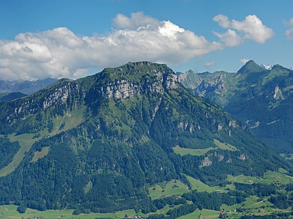
Rophaien
17 min walk • The Rophaien is a mountain of the Schwyzer Alps, overlooking Lake Lucerne in the canton of Uri. It lies west of the Rossstock, at the western end of the range north of the Schächental.
 Nature, Natural attraction, Mountain
Chaiserstock
90 min walk • The Chaiserstock is a mountain of the Schwyzer Alps, located on the border between the Swiss cantons of Schwyz and Uri. It lies on the range between Muotathal and Unterschächen, east of Lake Lucerne.
 Nature, Natural attraction, Mountain
Rossstock
72 min walk • The Rossstock is a mountain of the Schwyzer Alps, located on the border between the Swiss cantons of Schwyz and Uri. It lies on the range between Muotathal and Unterschächen, east of Lake Lucerne.
 Nature, Natural attraction, Mountain
Klingenstock
58 min walk • The Klingenstock is a mountain of the Schwyzer Alps, located between Stoos and Riemenstalden in the canton of Schwyz. Its summit is accessible by chair lift from Stoos.
 Nature, Natural attraction, Mountain
Fulen
80 min walk • The Fulen is a mountain peak of the Schwyz Alps, located on the border between the Swiss cantons of Schwyz and Uri. It lies on the range between Muotathal and Unterschächen, east of Lake Lucerne.
 Nature, Natural attraction, Lake
Spilauersee
52 min walk • Spilauersee is a lake in the Canton of Uri, Switzerland, below Rossstock. The lake can be reached by foot in half an hour from the Chäppeliberg–Lidernen cable car.


