Sallows, Ambleside
#24 among attractions in Ambleside
![Sallows location map](https://tzmedia.b-cdn.net/media/images/static-maps/gb/54_4274_-2_86943.jpg)
Facts and practical information
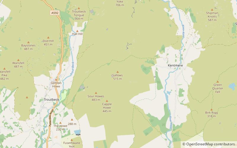
Sallows is a fell in the English Lake District, rising between the valleys of Kentmere and Troutbeck. It is the highest point in the upland area to the south of Garburn Pass, variously termed Kentmere Park and Applethwaite Common on Ordnance Survey maps. ()
Ambleside United Kingdom
Ambleside plan & book
Unleash the traveler in you — discover the cheapest flight deals, find the perfect hotel or hostel nearby, and search for the best car rental prices. Travel at your own pace to discover new places and enjoy your journey.
Sallows – popular in the area (distance from the attraction)
Nearby attractions include: Brockhole, Holehird Gardens, Kentmere Reservoir, Orrest Head.
3.5 miSWNature and wildlife, Park, Visitor centerBrockhole, Windermere
90 min walk • The Brockhole Lake District Visitor Centre, also known as the Brockhole National Park Visitor Centre, is a visitor centre and tourist attraction managed by the Lake District National Park Authority. It is situated on the shore of Lake Windermere, roughly equidistant between the towns of Bowness-on-Windermere and Ambleside.
2.5 miSWGarden, ParkHolehird Gardens, Windermere
65 min walk • Holehird Gardens is an extensive 10-acre site located near Windermere, Cumbria, England. It is the home of the Lakeland Horticultural Society.
2.6 miNNature, Natural attraction, LakeKentmere Reservoir
68 min walk • Kentmere Reservoir is a water storage facility situated in the Kentmere valley in the county of Cumbria, England. It is located 10.5 kilometres north-northeast of the town of Windermere.
3.2 miSWLookout, Historic walking areas, View pointOrrest Head, Windermere
81 min walk • Orrest Head is a hill in the English Lake District on the eastern shores of Windermere. It is the subject of a chapter in Wainwright's The Outlying Fells of Lakeland, and the first fell he climbed.
1.2 miEChurchSt Cuthbert's Church
31 min walk • St Cuthbert's Church, Kentmere is a Grade II listed parish church in the Church of England in Kentmere, Cumbria. Its benefice is united with that of St Martin's Church, Bowness-on-Windermere; St Anne's Church, Ings; St James' Church, Staveley; Jesus Church, Troutbeck and St Mary's Church, Windermere.
2.6 miSEHillHigh Knott, Windermere
66 min walk • High Knott, marked on some Ordnance Survey maps as Williamson's Monument, is a hill in the eastern part of the English Lake District, near Staveley, Cumbria. The monument on its summit was built by the Reverend T.
2.1 miSWMuseum, Historical placeTownend, Windermere
54 min walk • Townend is a 17th-century house located in Troutbeck, Windermere, Cumbria, England, and in the ownership of the National Trust. It was donated to the Trust in 1948. Prior to this it was the home of the Browne family, local farmers, for 400 years.
2.2 miWNature, Natural attraction, HillWansfell, Rydal
57 min walk • Wansfell is a fell in English Lake District situated 1½ miles east of the town of Ambleside. The fell is part of the long southern ridge of Caudale Moor and occupies the swath of territory between Ambleside and the Troutbeck valley.
1.8 miNNature, Natural attraction, HillYoke
45 min walk • Yoke is a fell in the Lake District in Cumbria, England. It has a height of 706 m and is situated in the far eastern sector of the national park, 6½ kilometres ENE of the town of Ambleside.
3.5 miSENature, Natural attraction, HillReston Scar
89 min walk • Reston Scar is a fell in the Lake District of Cumbria, England. It overlooks the north side of Staveley village, and is listed among Alfred Wainwright's "Outlying Fells of Lakeland" guide.
2.6 miNEHillShipman Knotts, Ambleside
68 min walk • Shipman Knotts is a fell in the English Lake District in Cumbria, England. It reaches a height of 587 metres and is situated in one of the quieter areas of the national park, 2 kilometres north-east of Kentmere village.