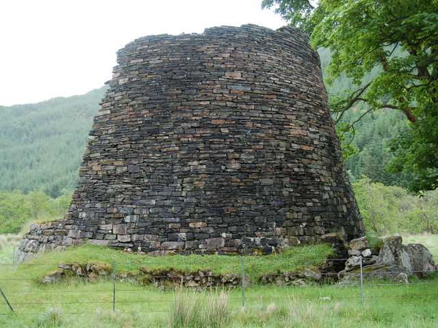
Dun Telve, Glenelg
#2 among attractions in Glenelg


Facts and practical information
Dun Telve is an iron-age broch located about 4 kilometres southeast of the village of Glenelg, Inverness-shire in the Highland Region of Scotland. It is one of the best preserved brochs in Scotland. ()
Dun Telve – popular in the area (distance from the attraction)
Nearby attractions include: Glenelg Inn, Beinn Sgritheall, Caisteal Maol, Dun Grugaig.
1.6 miNWNightlife, RestaurantGlenelg Inn, Glenelg
42 min walk • Glenelg Inn is a public house and inn in the village of Glenelg in the Highlands of Scotland. The current building dates to the second half of the 20th century, but remnants of the previous structure — the "imposing" Glenelg Hotel, which was largely destroyed in a 1947 fire — still stand.
2.9 miSNature, Natural attraction, MountainBeinn Sgritheall
74 min walk • Beinn Sgritheall is the highest mountain in the Glenelg area of the Highlands of Scotland. The main approach is via Arnisdale on the shores of Loch Hourn or via Gleann Beag to the north, with its well-known brochs.
7.2 miNWCastle ruins from the 15th centuryCaisteal Maol, Isle of Skye
183 min walk • Caisteal Maol is a ruined castle located near the harbour of the village of Kyleakin, Isle of Skye, Scotland. It is also known as Castle Moil, Castle Maol, Dun Akyn, Dunakin Castle Dun Haakon and Castle Dunakin.
1.6 miSEArchaeological siteDun Grugaig, Glenelg
41 min walk • Dun Grugaig is a D-shaped dun, or "semi-broch", located about 7 kilometres southeast of the village of Glenelg, Highland, in Scotland.
6.1 miNESmall island with an iconic castleEilean Donan, Dornie
155 min walk • Eilean Donan is a small tidal island situated at the confluence of three sea lochs in the western Highlands of Scotland, about 1 kilometre from the village of Dornie.
6.9 miSEMountainDruim Fada, Knoydart
175 min walk • Druim Fada is a mountain in the Northwest Highlands of Scotland. Located on the northern shore of Loch Hourn in Ross and Cromarty. A long, craggy ridge, it runs for several kilometres on the northern side of the loch. The nearest village is Arnisdale to the west.
~1590 ftEArchaeological siteDun Troddan, Glenelg
8 min walk • Dun Troddan is an iron-age broch located about 5 kilometres southeast of the village of Glenelg, Highland, in Scotland. It is one of the best-preserved brochs in Scotland.
5.2 miNWNature, Natural attraction, MountainSgùrr na Coinnich, Kyleakin
132 min walk • Sgùrr na Coinnich is the highest peak on the Sleat peninsula at the east end of the Isle of Skye. Together with its slightly lower neighbour, Beinn na Caillich, it overlooks the Skye Bridge that links the towns of Kyle of Lochalsh and Kyleakin.
1.8 miNWForts and castlesBernera Barracks, Glenelg
45 min walk • Bernera Barracks is located in Glenelg in the West Highlands of Scotland. The barracks were constructed between 1717 and 1723 as part of a campaign by the British government to subdue the local population which had risen up in arms in the Jacobite Rising of 1715, and which would do so again in 1745.
5.4 miNArchaeological siteCaisteal Grugaig
138 min walk • Caisteal Grugaig is an Iron Age broch near the eastern end of Loch Alsh in the Scottish Highlands.
5.1 miNWNature, Natural attraction, MountainBeinn na Caillich, Kyleakin
130 min walk • Beinn na Caillich is a mountain at the eastern end of the Isle of Skye, in Scotland. It is situated to the west of Kyle Rhea, about 4 km south-east of Kyleakin.