Falls of Dee, Cairngorms National Park
#98 among attractions in Cairngorms National Park

Facts and practical information
Falls of Dee is a waterfall on Braeriach in the Cairngorms, Scotland. ()
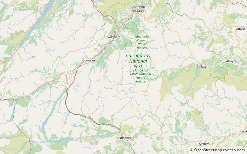
Cairngorms National Park United Kingdom
Cairngorms National Park plan & book
Unleash the traveler in you — discover the cheapest flight deals, find the perfect hotel or hostel nearby, and search for the best car rental prices. Travel at your own pace to discover new places and enjoy your journey.
Falls of Dee – popular in the area (distance from the attraction)
Nearby attractions include: Ben Macdui, Sgòr an Lochain Uaine, Loch Tilt, An Sgarsoch.
 Towering peak with trails to the summit
Ben Macdui, Cairngorms National Park
144 min walk • Ben Macdui is the second-highest mountain in Scotland after Ben Nevis, and the highest in the Cairngorm Mountains and the wider Cairngorms National Park. The summit elevation is 1,309 metres AMSL.
 Nature, Natural attraction, Mountain
Sgòr an Lochain Uaine, Cairngorms National Park
106 min walk • Sgòr an Lochain Uaine is a mountain in the Cairngorms, Scotland. By some counts it is the fifth-highest mountain in Scotland. It is the third-highest point in the western massif of the Cairngorms, lying between Braeriach and Cairn Toul on the western side of the pass of the Lairig Ghru.
 Lake
LakeLoch Tilt, Cairngorms National Park
154 min walk • Loch Tilt is a small mountain freshwater loch that sits at the end of Glen Tilt and is located in north-east Perth and Kinross, Scotland. Loch Tilt has a north to south orientation. Loch Tilt is located 10 miles southwest of Braemar.
 Mountain
An Sgarsoch, Cairngorms National Park
119 min walk • An Sgarsoch is a mountain in the Grampian Mountains of Scotland. It lies north in a very remote part of the Highlands, on the border of Aberdeenshire and Perthshire.
 Nature, Natural attraction, Mountain
Càrn a' Mhàim, Cairngorms National Park
105 min walk • Càrn a' Mhàim is a Scottish mountain situated in the inner part of the Cairngorms range, some 15 kilometres west of Braemar in the county of Aberdeenshire.
 Nature, Natural attraction, Mountain
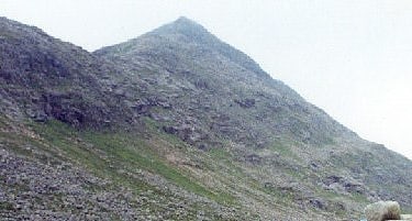
The Devil's Point, Cairngorms National Park
83 min walk • The Devil's Point is a mountain in the Cairngorms of Scotland, lying to the west of the Lairig Ghru pass. The Gaelic name means "Penis of the Demon". The English name is a result of a visit to the area by Queen Victoria.
 Mountain
Carn an Fhidhleir
125 min walk • Carn an Fhidhleir is a mountain in the Grampian Mountains of Scotland. It lies on the border of Inverness-shire, Perthshire and Aberdeenshire, in one of the most remote areas of Scotland between the Cairngorms and the Mounth.
 Nature, Natural attraction, Mountain
Cairn Toul, Cairngorms National Park
103 min walk • Cairn Toul is the fourth highest mountain in Scotland, The United Kingdom, and The British Isles, after Ben Nevis, Ben Macdui and Braeriach. The summit elevation is 1,291 metres AMSL.
 Nature, Natural attraction, Mountain
Sgòr Gaoith, Cairngorms National Park
140 min walk • Sgòr Gaoith is a mountain in the western massif of the Cairngorms, and is separated from the Braeriach massif by the broad valley of Glen Einich. The second-highest summit of the mountain is Sgoran Dubh Mòr, which lies 1.3 km away due NNE along the summit ridge.
 Nature, Natural attraction, Waterfall
Chest of Dee, Braemar
117 min walk • Chest of Dee is a waterfall of Scotland.
 Nature, Natural attraction, Mountain
Derry Cairngorm, Cairngorms National Park
160 min walk • Derry Cairngorm is a Scottish mountain in the Cairngorms range, 14 kilometres north west of Braemar in the county of Aberdeenshire.


