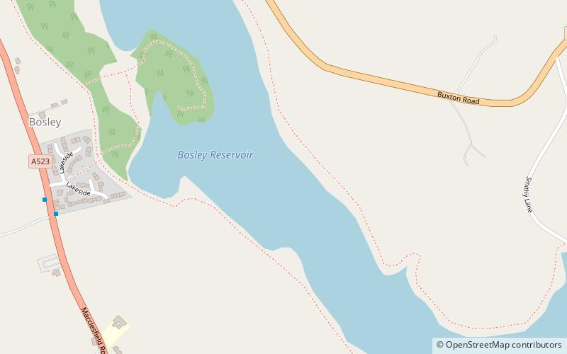
Bosley Reservoir
#3086 among destinations in the United Kingdom

Facts and practical information
Bosley Reservoir is a large reservoir created to feed the Macclesfield Canal system, specifically the twelve Bosley locks. It is fed from the surrounding hills, including Bosley Cloud which rises to 1,125 feet. ()
EnglandUnited Kingdom
Bosley Reservoir plan & book
Unleash the traveler in you — discover the cheapest flight deals, find the perfect hotel or hostel nearby, and search for the best car rental prices. Travel at your own pace to discover new places and enjoy your journey.
Bosley Reservoir – popular in the area (distance from the attraction)
Nearby attractions include: Congleton Museum, Lud's Church, Gawsworth Old Hall, The Cloud.
 Museum
Congleton Museum, Congleton
109 min walk • Congleton Museum is a local museum in Congleton, Cheshire, northwest England, covering the history of the town of Congleton, which is situated on the banks of the River Dane.
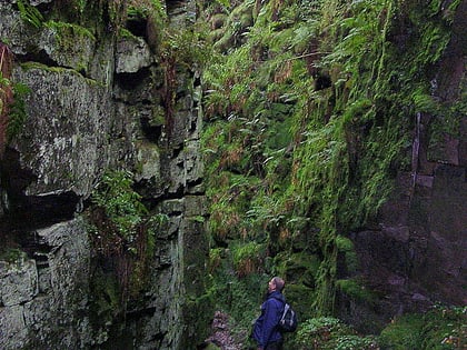 Nature, Natural attraction, Cave
Lud's Church, Peak District
104 min walk • Lud's Church is a deep chasm penetrating the Millstone Grit bedrock created by a massive landslip on the hillside above Gradbach, Staffordshire, England.
 Museum, History museum, Historical place
Gawsworth Old Hall
76 min walk • Gawsworth Old Hall is a Grade I listed country house in the village of Gawsworth, Cheshire, England. It is a timber-framed house in the Cheshire black-and-white style. The present house was built between 1480 and 1600, replacing an earlier Norman house.
 Nature, Natural attraction, Hill
The Cloud
46 min walk • The Cloud or Bosley Cloud is a prominent hill on the border between Cheshire and Staffordshire a couple of miles west of the Peak District National Park boundary. At 343 metres in height, it is one of the highest hills in the area.
 Nature, Natural attraction, Hill
Shutlingsloe, Peak District
104 min walk • Shutlingsloe is a hill near the village of Wildboarclough, in the east of the county of Cheshire. It stands to the south of Macclesfield Forest, on the edge of the Peak District and within the Peak District National Park.
 Church, Gothic Revival architecture
St Saviour's Church, Peak District
109 min walk • St Saviour's Church is in the village of Wildboarclough, Cheshire, England. It is an active Anglican parish church in the deanery of Macclesfield, the archdeaconry of Macclesfield, and the diocese of Chester.
 Church, Historical place, Gothic architecture
St James' Church, Macclesfield
78 min walk • St James' Church is in the village of Gawsworth, Cheshire, England, and is sited near Gawsworth Hall. It is recorded in the National Heritage List for England as a designated Grade I listed building. It is an active Anglican parish church in the diocese of Chester, the archdeaconry of Macclesfield and the deanery of Macclesfield.
 Archaeological site
The Bridestones
65 min walk • The Bridestones is a chambered cairn, near Congleton, Cheshire, England, that was constructed in the Neolithic period about 3500–2400 BC.
 Church
St Michael's Church
53 min walk • St Michael's Church is in Church Lane, North Rode, Cheshire, England. It is an active Anglican parish church in the deanery of Macclesfield, the archdeaconry of Macclesfield, and the diocese of Chester.
 Hiking, Hiking trail
Gritstone Trail
63 min walk • The Gritstone Trail, or Cheshire Gritstone Trail, is a 35-mile long-distance footpath in England which follows the most westerly hills of the Peak District from Disley Station to Mow Cop, and on via the Macclesfield Canal to Kidsgrove Station.
 Church
Church of St Mary the Virgin
9 min walk • The Church of St Mary the Virgin is in Leek Road, Bosley, Cheshire, England. It is recorded in the National Heritage List for England as a designated Grade II* listed building. It is an active Anglican parish church in the diocese of Chester, the archdeaconry of Macclesfield, and the deanery of Macclesfield.


