Shutlingsloe, Peak District
#33 among attractions in Peak District
Facts and practical information
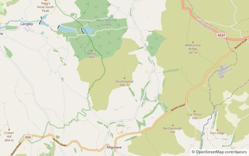
Shutlingsloe is a hill near the village of Wildboarclough, in the east of the county of Cheshire. It stands to the south of Macclesfield Forest, on the edge of the Peak District and within the Peak District National Park. ()
Peak District United Kingdom
Peak District plan & book
Unleash the traveler in you — discover the cheapest flight deals, find the perfect hotel or hostel nearby, and search for the best car rental prices. Travel at your own pace to discover new places and enjoy your journey.
Shutlingsloe – popular in the area (distance from the attraction)
Nearby attractions include: Lud's Church, Tegg's Nose, Cats Tor, St Saviour's Church.
- 2.5 miSNature, Natural attraction, Cave
Lud's Church, Peak District
65 min walk • Lud's Church is a deep chasm penetrating the Millstone Grit bedrock created by a massive landslip on the hillside above Gradbach, Staffordshire, England.
- 2.5 miNWNature, Natural attraction, Hill
Tegg's Nose
65 min walk • Tegg's Nose is a hill east of Macclesfield in Cheshire, England. It has a short ridge with a high point of 380 metres at SJ947725, terminating in a promontory at the southern end.
- 4.1 miNHill
Cats Tor, Peak District
105 min walk • Cats Tor is a Peak District hill on the border between Cheshire and Derbyshire, between the towns of Macclesfield and Buxton. The summit is 518 metres above sea level. Tor is an Old English word for a high, rocky hill. The higher peak of Shining Tor is about 2 km south along The Tors gritstone ridge.
- 0.7 miSEChurch, Gothic Revival architecture
St Saviour's Church, Peak District
18 min walk • St Saviour's Church is in the village of Wildboarclough, Cheshire, England. It is an active Anglican parish church in the deanery of Macclesfield, the archdeaconry of Macclesfield, and the diocese of Chester.
- 2.8 miNENature, Natural attraction, Hill
Shining Tor, Peak District
72 min walk • Shining Tor is the highest hill in the modern ceremonial county of Cheshire, England. The summit has a maximum elevation of 559 m above sea level.
- 4 miNEMountain
Burbage Edge, Peak District
102 min walk • Burbage Edge is a gritstone escarpment overlooking the Burbage district of Buxton in Derbyshire, in the Peak District. The hill's summit is 500 metres above sea level. Not to be confused with the Burbage Rocks extension of Stanage Edge near Hathersage.
- 1.6 miNChurch
Forest Chapel, Peak District
41 min walk • Forest Chapel stands in an isolated position in the civil parish of Macclesfield Forest and Wildboarclough in Cheshire, England, within the Peak District National Park 4.5 miles from Macclesfield. It is recorded in the National Heritage List for England as a designated Grade II listed building.
- 3.9 miNWGothic Revival architecture, Church
St Peter's Church, Macclesfield
101 min walk • St Peter's Church is in Windmill Street, Macclesfield, Cheshire, England. It is an active Anglican parish church in the diocese of Chester, the archdeaconry of Macclesfield, and the deanery of Macclesfield.
- 2.4 miSWChurch, Gothic Revival architecture
St Michael's Church, Peak District
62 min walk • St Michael's Church is in the village of Wincle, Cheshire, England. It is an active Anglican parish church in the diocese of Chester, the archdeaconry of Macclesfield and the deanery of Macclesfield.
- 1.2 miNWNature, Natural attraction, Forest
Macclesfield Forest, Peak District
32 min walk • Macclesfield Forest is an area of woodland, predominantly conifer plantation, located around 3 mi south east of Macclesfield in the civil parish of Macclesfield Forest and Wildboarclough, in Cheshire, England.
- 4 miSWNature, Natural attraction, Lake
Bosley Reservoir
104 min walk • Bosley Reservoir is a large reservoir created to feed the Macclesfield Canal system, specifically the twelve Bosley locks. It is fed from the surrounding hills, including Bosley Cloud which rises to 1,125 feet.