Swaythling Baptist Church, Southampton
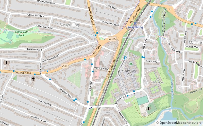
Map
Facts and practical information
The Swaythling and Bassett Covenant of Churches is an ecumenical group made up of the following churches: ()
Coordinates: 50°56'20"N, 1°22'46"W
Address
Fleming RdRomsey and Southampton North (Swaythling)Southampton SO16 2JD
Contact
+44 23 8067 9295
Social media
Add
Getting there by public transportation
Public transportation stops near this location
- Bus
- Train
 Bus
Bus
- Calculate routeFriars Way 4 min walk
- Calculate routeWessex Lane Halls 4 min walk
- Calculate routeHigh Road 5 min walk
- Calculate routeSwaythling 5 min walk
- Calculate routeSouthampton Airport Parkway 28 min walk
- Calculate routeSt Denys 31 min walk
Day trips


Frequently Asked Questions (FAQ)
Which popular attractions are close to Swaythling Baptist Church?
Nearby attractions include South Stoneham House, Southampton (5 min walk), St. Mary's Church, Southampton (7 min walk), St Alban's Church, Southampton (9 min walk), South Stoneham Cemetery, Southampton (13 min walk).
How to get to Swaythling Baptist Church by public transport?
The nearest stations to Swaythling Baptist Church:
Bus
Train
Bus
- Friars Way • Lines: U1A (4 min walk)
- Wessex Lane Halls • Lines: U1, U1A (4 min walk)
Train
- Swaythling (5 min walk)
- Southampton Airport Parkway (28 min walk)