Basedale Priory, North York Moors
#51 among attractions in North York Moors
![Basedale Priory location map](https://tzmedia.b-cdn.net/media/images/static-maps/gb/54_4518_-1_04448.jpg)
Facts and practical information
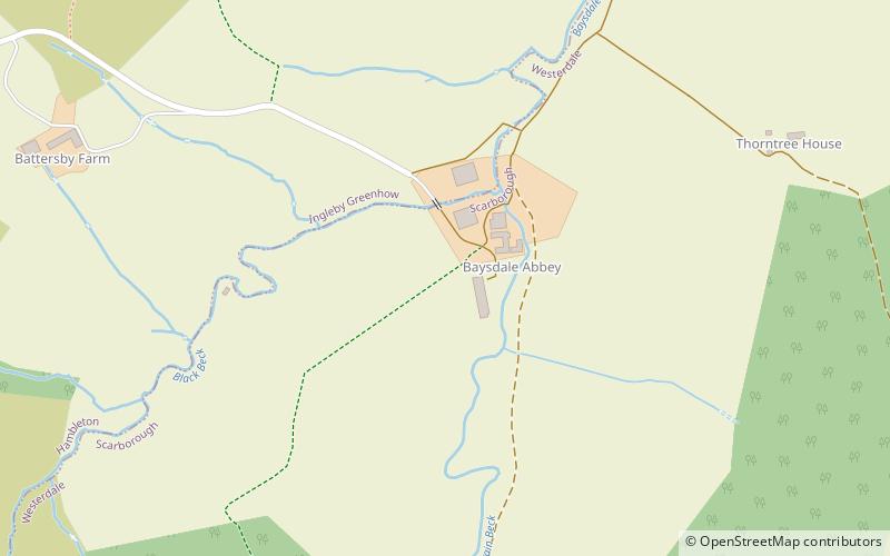
Basedale Priory or Baysdale Priory was a priory in North Yorkshire, England located 8 miles East from the parish church of Stokesley. It was a house of Cistercian nuns established in the 12th century and suppressed in 1539. ()
North York Moors United Kingdom
North York Moors plan & book
Unleash the traveler in you — discover the cheapest flight deals, find the perfect hotel or hostel nearby, and search for the best car rental prices. Travel at your own pace to discover new places and enjoy your journey.
Basedale Priory – popular in the area (distance from the attraction)
Nearby attractions include: Lion Inn, Roseberry Topping, Easby Moor, Hasty Bank.
5.6 miSENightlifeLion Inn, Kirkbymoorside
144 min walk • The Lion Inn is a public house at Blakey Ridge, near Kirkbymoorside, in North Yorkshire, England. The building was completed between 1553 and 1558, and has been used as an inn for four centuries, sitting adjacent to a road across the moors between Castleton and Hutton-le-Hole.
4.5 miNWNature, Natural attraction, MountainRoseberry Topping, North York Moors
115 min walk • Roseberry Topping is a distinctive hill in North Yorkshire, England. It is situated near Great Ayton and Newton under Roseberry.
2.8 miNWNature, Natural attraction, MountainEasby Moor, North York Moors
73 min walk • Easby Moor is a hill located in the civil parish of Little Ayton in the North York Moors national park within the Cleveland Hills, North Yorkshire, England.
3.8 miSWNature, Natural attraction, MountainHasty Bank, North York Moors
98 min walk • Hasty Bank is a hill in the Cleveland Hills range of the North York Moors, in north-east England. The Cleveland Way National Trail crosses Hasty Bank and is part of Wainwright's Coast to Coast Walk.
5.6 miSWNature, Natural attraction, MountainCringle Moor, North York Moors
144 min walk • Cringle Moor, at 432 m, is the third highest hill in the North York Moors, England, and the highest point west of Clay Bank.
4.3 miEHiking, Hiking trailEsk Valley Walk, North York Moors
110 min walk • The Esk Valley Walk is a long distance footpath in North Yorkshire, England. The route first follows a loop on the North York Moors to the south of Castleton, then shadows the River Esk on its journey to the North Sea.
3.5 miSWNature, Natural attraction, MountainUrra Moor, North York Moors
91 min walk • Urra Moor is the highest moor in the North York Moors, North Yorkshire, England. At 1,490 feet above sea level it is the highest point in Hambleton District and the North York Moors National Park, and the fourteenth most prominent hill in England.
5.2 miNArchaeological siteRuther Cross, Guisborough
134 min walk • Ruther Cross is the shaft of an old stone cross in Guisborough in Redcar and Cleveland, England. It stands close to the point where the old road Ruthergate used to cross Hutton Lane. The cross was designated Grade II listed in April 1984.
4.4 miNW54°29'19"N • 1°8'4"WCaptain Cook Schoolroom Museum, Great Ayton
113 min walk • Specialty museum, Museum
5.8 miNW54°31'45"N • 1°5'54"WFriends of Guisborough Forest & Walkway, Guisborough
147 min walk • Nature, Visitor center, Natural attraction
7.1 miNENature, Natural attraction, ForestPinkney and Gerrick Woods, North York Moors
181 min walk • Pinkney And Gerrick Woods is a 62.7 hectare biological Site of Special Scientific Interest in North Yorkshire, England notified in 1954. SSSIs are designated by Natural England, formally English Nature, which uses the 1974–1996 county system.