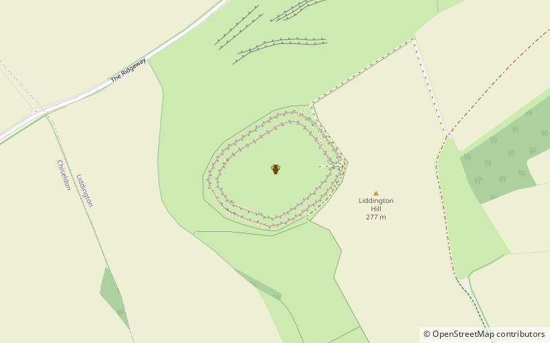
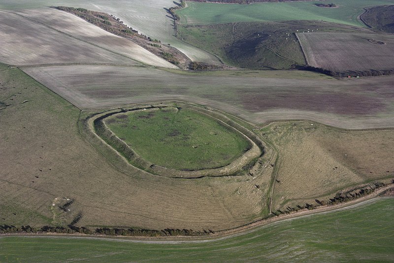
Liddington Castle
#725 among destinations in the United Kingdom
![Liddington Castle location map](https://tzmedia.b-cdn.net/media/images/static-maps/gb/51_5158_-1_70036.jpg)
![Liddington Castle](https://tzmedia.b-cdn.net/media/images/gb/place/gallery/medium/5e7e9cb986d60426126896b2611fcf3a.jpg)
Facts and practical information
Liddington Castle, locally called Liddington Camp, is a late Bronze Age and early Iron Age univallate hill fort in the English county of Wiltshire. At 277 metres, it is the highest point in the Borough of Swindon. ()
Liddington Castle – popular in the area (distance from the attraction)
Nearby attractions include: Coate Water, Barbury Castle, Christ Church, Swindon Art Gallery.
2.7 miNWPark, Nature and wildlife, Body of waterCoate Water, Swindon
70 min walk • Coate Water is a country park situated 5 km to the southeast of central Swindon, England, near junction 15 of the M4. It takes its name from its main feature, a reservoir originally built to provide water for the Wilts & Berks Canal.
4.2 miSWArchaeological site, Forts and castlesBarbury Castle
107 min walk • Barbury Castle is a scheduled hill fort situated in Wiltshire, England. It is one of several such forts found along the ancient Ridgeway route.
4.1 miNWChurchChrist Church, Swindon
106 min walk • Christ Church is a grade II* listed church in Cricklade Street, Swindon, Wiltshire, England. It was built in 1851 to a design by George Gilbert Scott. The church is one of two major buildings in Old Town, the other being the old town hall, only a few minutes walk away.
4.2 miNWMuseum, Art museumSwindon Art Gallery, Swindon
107 min walk • Swindon Museum and Art Gallery is located in Swindon, Wiltshire, England, in a listed building on the corner of Bath Road and Victoria Road in Swindon's Old Town. The Swindon Art Gallery has a collection of 20th-century British art which was established in 1944 by a local benefactor, H.J.P.
2.1 miNAreaWanborough, Swindon
54 min walk • Wanborough is a large village and civil parish in the borough of Swindon, Wiltshire, England. The village is about 3.5 miles southeast of Swindon town centre.
1.8 miNChurchSt Andrew's Church
46 min walk • St Andrew's Church is in the village of Wanborough in north Wiltshire, England. It is an active Anglican parish church in the Diocese of Bristol, one of only three churches in England to have a western tower and a central spire.
4.1 miNWConcerts and shows, TheaterSwindon Arts Centre, Swindon
105 min walk • Swindon Arts Centre is a 212-seat entertainment venue located in the Old Town area of Swindon, Wiltshire, England. It opened in 1956. The Swindon Arts Centre is situated at the heart of Swindon's Old Town on Devizes Road.
3.9 miWVillage, AreaWroughton, Swindon
101 min walk • Wroughton is a large village and civil parish in northeast Wiltshire, England. It is part of the Borough of Swindon and lies along the A4361 road between Swindon and Avebury; the road into Swindon crosses the M4 motorway between junctions 15 and 16.
4.4 miWParkClout's Wood, Swindon
114 min walk • Clout's Wood is an 11.78 hectare biological Site of Special Scientific Interest in Wiltshire, notified in 1951. The site is managed as a nature reserve by Wiltshire Wildlife Trust.
2.7 miNW 2.4 miNWArchaeological siteDay House Lane Stone Circle, Swindon
61 min walk • Day House Lane Stone Circle, also known as Coate Stone Circle, is a stone circle near the hamlet of Coate, now on the southeastern edge of Swindon, in the English county of Wiltshire. Five partly buried stones remain at the site.