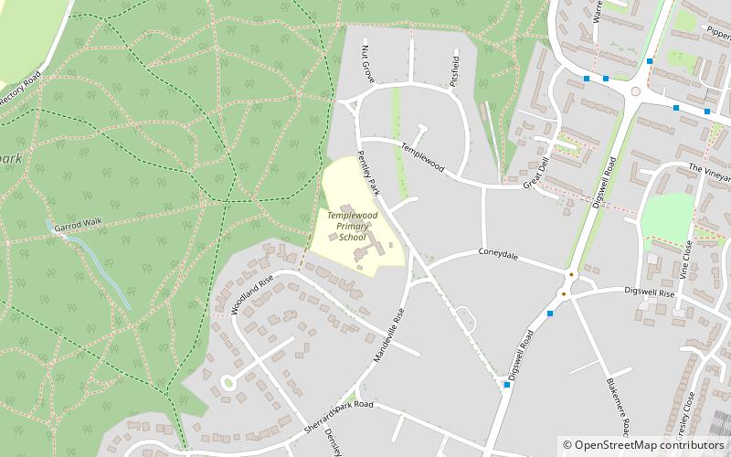
Templewood Primary School, Welwyn Garden City
Map
Facts and practical information
Templewood Primary School is a primary school in Pentley Park, Welwyn Garden City, Hertfordshire, England. It is one of a number of modernist schools commissioned by the Hertfordshire County Council in the 20th century and is a Grade II* listed building. ()
Coordinates: 51°48'37"N, 0°12'33"W
Address
Welwyn Garden City
ContactAdd
Social media
Add
Getting there by public transportation
Public transportation stops near this location
- Bus
- Train
 Bus
Bus
- Calculate routePentley Park 6 min walk
- Calculate routeKnightsfield 9 min walk
- Calculate routeHarwood Hill 9 min walk
- Calculate routeCampus West 9 min walk
- Calculate routeWelwyn Garden City 18 min walk
- Calculate routeWelwyn North 31 min walk
Day trips


Frequently Asked Questions (FAQ)
Which popular attractions are close to Templewood Primary School?
Nearby attractions include New Maynard Gallery, Welwyn Garden City (9 min walk), Sherrardspark Wood, Welwyn Garden City (9 min walk), Stanborough Reedmarsh, Welwyn Garden City (9 min walk), Welwyn Hatfield Borough Council, Welwyn Garden City (15 min walk).
How to get to Templewood Primary School by public transport?
The nearest stations to Templewood Primary School:
Bus
Train
Bus
- Pentley Park • Lines: 403 (6 min walk)
- Knightsfield • Lines: 403 (9 min walk)
Train
- Welwyn Garden City (18 min walk)
- Welwyn North (31 min walk)