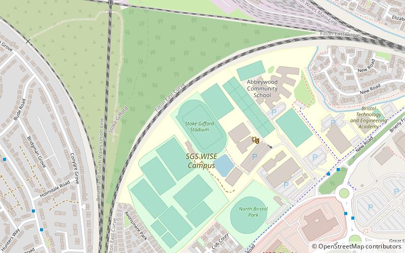
Stoke Gifford Stadium, Bristol
Map
Facts and practical information
Stoke Gifford Stadium is an association football stadium based in Filton, in South Gloucestershire, England. Until August 2020 it was the home of FA Women's Super League team Bristol City W.F.C. and the Bristol Aztecs american football team. It is part of the South Gloucestershire and Stroud College and was opened in 2011 under the name of Kip Keino Athletic Stadium as it has an athletics track around it. ()
Coordinates: 51°30'46"N, 2°33'25"W
Address
Bristol
ContactAdd
Social media
Add
Getting there by public transportation
Public transportation stops near this location
- Bus
- Train
 Bus
Bus
- Calculate routeParkway Tavern 14 min walk
- Calculate routeRatcliffe Drive 14 min walk
- Calculate routeBristol Parkway Station 15 min walk
- Calculate routeBristol Parkway 16 min walk
- Calculate routeFilton Abbey Wood 18 min walk
- Calculate routePatchway 24 min walk
Day trips


Frequently Asked Questions (FAQ)
How to get to Stoke Gifford Stadium by public transport?
The nearest stations to Stoke Gifford Stadium:
Bus
Train
Bus
- Parkway Tavern • Lines: Y6 (14 min walk)
- Ratcliffe Drive • Lines: Y6 (14 min walk)
Train
- Bristol Parkway (16 min walk)
- Filton Abbey Wood (18 min walk)