Mile Rocks Lighthouse, San Francisco
Map

Gallery

Facts and practical information
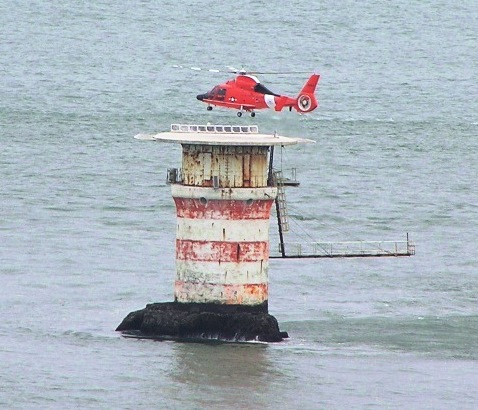
Mile Rocks Lighthouse is located on a rock about 1 mile southwest of the Golden Gate Bridge, off of Lands End in San Francisco, California. It was completed in 1906, replacing a nearby bell buoy. In 1966, the light was automated, and the original 85 m tower of the lighthouse was demolished and replaced by a helipad. The lighthouse was at one time painted with alternating red and white rings, but as of 2017, the lighthouse is painted plain white. ()
Address
San Francisco
ContactAdd
Social media
Add
Day trips
Mile Rocks Lighthouse – popular in the area (distance from the attraction)
Nearby attractions include: Legion of Honor Museum, Lands End, USS San Francisco Memorial, Holocaust Memorial.
Frequently Asked Questions (FAQ)
Which popular attractions are close to Mile Rocks Lighthouse?
Nearby attractions include USS San Francisco Memorial, San Francisco (18 min walk), Lands End, San Francisco (18 min walk), Lincoln Park, San Francisco (19 min walk), Holocaust Memorial, San Francisco (19 min walk).
How to get to Mile Rocks Lighthouse by public transport?
The nearest stations to Mile Rocks Lighthouse:
Bus
Trolleybus
Bus
- Fort Miley Hospital • Lines: 38 (21 min walk)
- 43rd Avenue & Clement Street • Lines: 38 (23 min walk)
Trolleybus
- 32nd Avenue & California Street • Lines: 1 (30 min walk)
- 33rd Avenue & Clement Street • Lines: 1 (31 min walk)

 Muni Metro


