Bayswater Point State Park, New York City
Map
Facts and practical information
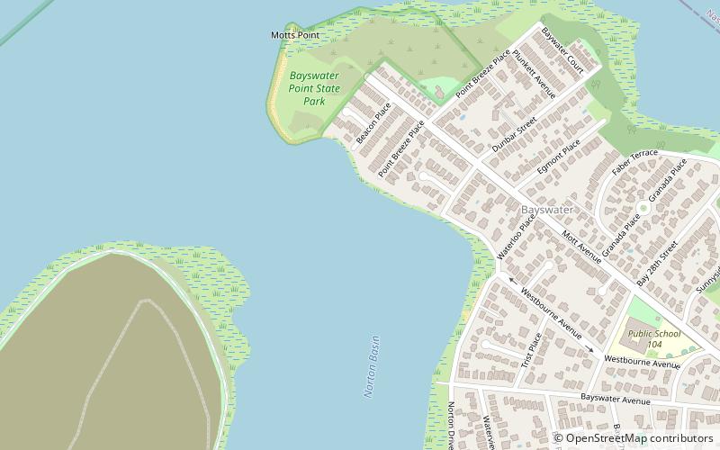
Bayswater Point State Park is a 17-acre state park located on Jamaica Bay in Queens, New York. The park is located at the western end of Mott Avenue in Bayswater near Far Rockaway and is built on land that once housed the mansion and estate of banker Louis A. Heinsheimer. ()
Created: 1991Visitors per year: 17.6 thous.Elevation: 0 ft a.s.l.Coordinates: 40°36'36"N, 73°46'18"W
Getting there by public transportation
Public transportation stops near this location
- Metro
- Train
 Metro
Metro
- Calculate routeBeach 25th Street 23 min walk
- Calculate routeFar Rockaway–Mott Avenue 26 min walk
- Calculate routeBeach 36th Street 27 min walk
- Calculate routeFar Rockaway 29 min walk
Maps SubwayMaps
 Manhattan Buses
SubwayMapsManhattan BusesDay trips


Frequently Asked Questions (FAQ)
How to get to Bayswater Point State Park by public transport?
The nearest stations to Bayswater Point State Park:
Metro
Train
Metro
- Beach 25th Street • Lines: A (23 min walk)
- Far Rockaway–Mott Avenue • Lines: A (26 min walk)
Train
- Far Rockaway (29 min walk)