Thirlby Field, Traverse City
Map
Facts and practical information
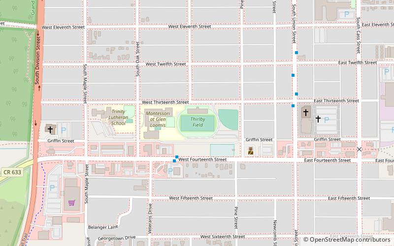
Thirlby Field is a 7,000-seat football stadium located in Traverse City, Michigan. It was built in 1934 on a site where football has been played since 1896 by the Traverse City Trojans. It is the home of the Traverse City Central Trojans, Traverse City West Titans and St. Francis Gladiators. ()
Opened: 1896 (130 years ago)Capacity: 7000Coordinates: 44°45'10"N, 85°37'41"W
Address
410 W Thirteenth StCentral Traverse CityTraverse City 49684
ContactAdd
Social media
Add
Getting there by public transportation
Public transportation stops near this location
- Bus
 Bus
Bus
- Calculate route14th Street & Veterans Drive 3 min walk
- Calculate routeUnion Street @ 10th Street 10 min walk
Day trips


Frequently Asked Questions (FAQ)
Which popular attractions are close to Thirlby Field?
Nearby attractions include Central Neighborhood Historic District, Traverse City (10 min walk), South Union Street–Boardman River Bridge, Traverse City (17 min walk), American Legion Memorial Bridge, Traverse City (18 min walk), City Opera House, Traverse City (21 min walk).
How to get to Thirlby Field by public transport?
The nearest stations to Thirlby Field:
Bus
Bus
- 14th Street & Veterans Drive • Lines: 1 (3 min walk)
- Union Street @ 10th Street • Lines: 1 (10 min walk)