Pleasanton Fairgrounds Racetrack, Pleasanton
Map
Facts and practical information
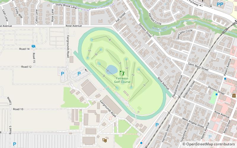
The Pleasanton Fairgrounds Racetrack at the Alameda County Fairgrounds in Pleasanton, California is a one-mile race track for Thoroughbred, Quarter horse and Arabian racing. Constructed in 1858 by the sons of Spaniard Don Agustín Bernal, it is the third-oldest horse racing track of its kind in the United States. Only the Freehold Raceway in New Jersey and Fair Grounds Race Course in Louisiana are older. ()
Opened: 1858 (168 years ago)Coordinates: 37°39'47"N, 121°53'2"W
Address
4501 Pleasanton AvePleasanton
ContactAdd
Social media
Add
Getting there by public transportation
Public transportation stops near this location
- Bus
- Train
 Bus
Bus
- Calculate routePleasanton ACE Station 8 min walk
- Calculate routePeters Avenue & Division Street 11 min walk
- Calculate routeNeal Street & 1st Street 15 min walk
- Calculate routePleasanton 9 min walk
Day trips


Frequently Asked Questions (FAQ)
Which popular attractions are close to Pleasanton Fairgrounds Racetrack?
Nearby attractions include Alameda County Fairgrounds, Pleasanton (8 min walk), Pleasanton Public Library, Pleasanton (11 min walk), Museum on Main, Pleasanton (12 min walk), Pleasanton Veterans Memorial, Pleasanton (13 min walk).
How to get to Pleasanton Fairgrounds Racetrack by public transport?
The nearest stations to Pleasanton Fairgrounds Racetrack:
Bus
Train
Bus
- Pleasanton ACE Station • Lines: 53, 54, 92X (8 min walk)
- Peters Avenue & Division Street • Lines: 10R (11 min walk)
Train
- Pleasanton (9 min walk)