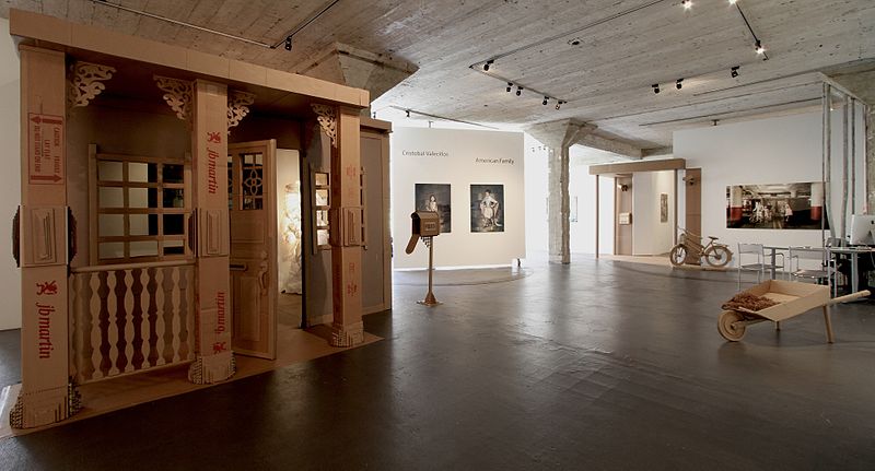
The McLoughlin Gallery, San Francisco

Gallery (3)
Map
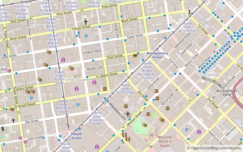
Map
Gallery
Facts and practical information
The McLoughlin Gallery was an art gallery established in 2010 by Joan McLoughlin that presented contemporary art from mid-career and emerging artists. The gallery was located at 49 Geary Street, Suite 200 San Francisco, California, United States. The McLoughlin gallery was the third largest space at 49 Geary. Artists at the gallery worked with a variety of different, and sometimes non-traditional, materials including: resins, plastics, Xeroxes, glitter, wood panel, acrylic and found objects. ()
Established: 2010 (16 years ago)Coordinates: 37°47'16"N, 122°24'14"W
Address
Northeast San Francisco (Downtown San Francisco-Union Square)San Francisco
Contact
Social media
Add
Getting there by public transportation
Public transportation stops near this location
- Metro
- Bus
- Trolleybus
- Tram
- Light rail
- Train
- Ferry
 Metro
Metro
- Calculate routeGeary Street & Kearny Street 1 min walk
- Calculate routeKearny Street & Geary Street 2 min walk
- Calculate routeMarket Street & 3rd Street 2 min walk
- Calculate routeMarket Street & Montgomery Street 3 min walk
- Calculate routeMarket Street & 3rd Street 1 min walk
- Calculate routeKearny Street & Geary Street 2 min walk
- Calculate route3rd Street & Mission Street 4 min walk
- Calculate routeMission Street & 3rd Street 4 min walk
- Calculate routeStockton Street & Geary Street 4 min walk
- Calculate routeMontgomery Street 4 min walk
- Calculate routePowell Street 8 min walk
- Calculate routeEmbarcadero 14 min walk
- Calculate routeCivic Center 20 min walk
- Calculate routeMontgomery Street 5 min walk
- Calculate routePowell Street 7 min walk
- Calculate routeEmbarcadero 14 min walk
- Calculate routeFerry Building Gate F 22 min walk
- Calculate routeSan Francisco 4th & King Street 24 min walk
Maps Muni Metro
Muni MetroDay trips


Frequently Asked Questions (FAQ)
Which popular attractions are close to The McLoughlin Gallery?
Nearby attractions include Robert Koch Gallery, San Francisco (1 min walk), Fraenkel Gallery, San Francisco (1 min walk), Lotta's Fountain, San Francisco (2 min walk), Ritz-Carlton Club and Residences, San Francisco (2 min walk).
How to get to The McLoughlin Gallery by public transport?
The nearest stations to The McLoughlin Gallery:
Bus
Tram
Trolleybus
Light rail
Metro
Ferry
Train
Bus
- Geary Street & Kearny Street • Lines: 38, 38R (1 min walk)
- Kearny Street & Geary Street • Lines: 30, 8, 91 (2 min walk)
Tram
- Market Street & 3rd Street • Lines: F (1 min walk)
Trolleybus
- Kearny Street & Geary Street • Lines: 30, 45 (2 min walk)
- 3rd Street & Mission Street • Lines: 30, 45 (4 min walk)
Light rail
- Montgomery Street • Lines: K, N, S, T (4 min walk)
- Powell Street • Lines: K, N, S, T (8 min walk)
Metro
- Montgomery Street • Lines: Blue, Green, Red, Yellow (5 min walk)
- Powell Street • Lines: Blue, Green, Red, Yellow (7 min walk)
Ferry
- Ferry Building Gate F • Lines: San Francisco Bay Ferry (22 min walk)
Train
- San Francisco 4th & King Street (24 min walk)