Central Embarcadero Piers Historic District, San Francisco

Gallery (1)
Map
Map
Facts and practical information
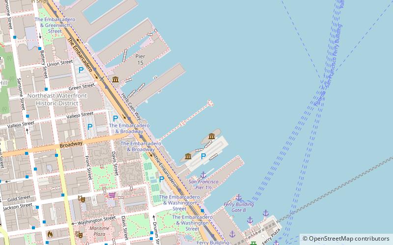
The Central Embarcadero Piers Historic District is a Registered Historic District in the City of San Francisco, California, United States. It consists of Piers 1, 1½, 3 and 5, is one of the largest surviving pier complexes along San Francisco's Embarcadero. The Central Embarcadero Piers Historic District was added to the National Register of Historic Places on November 20, 2002. ()
Built: 1918 (108 years ago)Coordinates: 37°47'58"N, 122°23'42"W
Address
Northeast San Francisco (Northern Waterfront)San Francisco
ContactAdd
Social media
Add
Getting there by public transportation
Public transportation stops near this location
- Metro
- Bus
- Trolleybus
- Tram
- Light rail
- Ferry
 Metro
Metro
- Calculate routeThe Embarcadero & Broadway 4 min walk
- Calculate routeFerry Building 8 min walk
- Calculate routeFerry Building Gate B 6 min walk
- Calculate routePier 41 Gate 2 30 min walk
- Calculate routeSan Francisco Ferry Building 6 min walk
- Calculate routeDrumm Street & Clay Street 8 min walk
- Calculate routeBattery Street & Broadway 9 min walk
- Calculate routeSteuart Street & Market Street 9 min walk
- Calculate routeClay Street & Drumm Street 8 min walk
- Calculate routeMarket Street & Steuart Street 9 min walk
- Calculate routeSacramento Street & Davis Street 10 min walk
- Calculate routeEmbarcadero 12 min walk
- Calculate routeMontgomery Street 21 min walk
- Calculate routePowell Street 31 min walk
- Calculate routeEmbarcadero 12 min walk
- Calculate routeFolsom 19 min walk
- Calculate routeMontgomery Street 21 min walk
- Calculate routeBrannan 29 min walk
Maps Muni Metro
Muni MetroDay trips


Frequently Asked Questions (FAQ)
Which popular attractions are close to Central Embarcadero Piers Historic District?
Nearby attractions include Embarcadero, San Francisco (1 min walk), Ferryboat Santa Rosa, San Francisco (3 min walk), Exploratorium, San Francisco (7 min walk), Sydney G. Walton Square, San Francisco (7 min walk).
How to get to Central Embarcadero Piers Historic District by public transport?
The nearest stations to Central Embarcadero Piers Historic District:
Tram
Ferry
Bus
Trolleybus
Metro
Light rail
Tram
- The Embarcadero & Broadway • Lines: F (4 min walk)
- Ferry Building • Lines: F (8 min walk)
Ferry
- Ferry Building Gate B • Lines: San Francisco Bay Ferry (6 min walk)
- Pier 41 Gate 2 • Lines: Blue & Gold Fleet, San Francisco Bay Ferry (30 min walk)
Bus
- San Francisco Ferry Building • Lines: 82 (6 min walk)
- Drumm Street & Clay Street • Lines: 292, 397, 398, Fcx (8 min walk)
Trolleybus
- Clay Street & Drumm Street • Lines: 1 (8 min walk)
- Market Street & Steuart Street • Lines: 14 (9 min walk)
Metro
- Embarcadero • Lines: Blue, Green, Red, Yellow (12 min walk)
- Montgomery Street • Lines: Blue, Green, Red, Yellow (21 min walk)
Light rail
- Embarcadero • Lines: K, N, S, T (12 min walk)
- Folsom • Lines: N, S, T (19 min walk)