Oakland East Bay Symphony, Oakland

Map
Facts and practical information
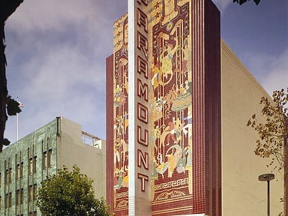
The Oakland East Bay Symphony is a leading orchestra based in Oakland, California. Michael Morgan held the position of music director and conductor from September 1990 until his death in August 2021. The Paramount Theatre has been the home of the Symphony since 1995. Bryan Nies has been Associate Conductor since 2002. The Symphony presents six programs of music during the season. ()
Founded: 1988 (38 years ago)Coordinates: 37°48'17"N, 122°16'16"W
Address
1440 BroadwayCentral Oakland (Downtown Oakland)Oakland 94612-2041
Contact
+1 510-444-0801
Social media
Add
Day trips
Oakland East Bay Symphony – popular in the area (distance from the attraction)
Nearby attractions include: Fox Theater, Paramount Theatre, Uptown Oakland, African American Museum and Library at Oakland.
Frequently Asked Questions (FAQ)
Which popular attractions are close to Oakland East Bay Symphony?
Nearby attractions include Pro Arts Gallery, Oakland (2 min walk), Lincoln University, Oakland (2 min walk), Frank H. Ogawa Plaza, Oakland (2 min walk), Oakland City Hall, Oakland (2 min walk).
How to get to Oakland East Bay Symphony by public transport?
The nearest stations to Oakland East Bay Symphony:
Bus
Metro
Train
Ferry
Bus
- Broadway & 14th Street • Lines: 18, 33, 6, 72, 72M, 72R, 800, 802, 805, 840 (1 min walk)
- 14th Street & Broadway • Lines: 14, 800 (2 min walk)
Metro
- Oakland City Center - 12th Street • Lines: Orange, Red, Yellow (3 min walk)
- 19th Street Oakland • Lines: Orange, Red, Yellow (7 min walk)
Train
- Oakland-Jack London Square (20 min walk)
Ferry
- Oakland Jack London Square Terminal • Lines: San Francisco Bay Ferry (23 min walk)


