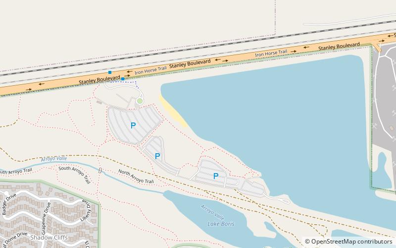
Shadow Cliffs Regional Recreation Area, Pleasanton
Map
Facts and practical information
Shadow Cliffs Regional Recreation Area is a regional park on the border of Pleasanton and Livermore, California, that is part of the East Bay Regional Parks system. Its lake, once a gravel pit, has a sandy beach and is used for swimming, fishing, and recreational boating. The park once featured water slides, which were closed in 2011 and have since been taken down, and are planned to be replaced by an Interpretive Center. The park is also a popular picnic ground. ()
Created: 1971Elevation: 348 ft a.s.l.Coordinates: 37°40'13"N, 121°50'28"W
Getting there by public transportation
Public transportation stops near this location
- Bus
 Bus
Bus
- Calculate routeShadow Cliffs Regional Recreation Area 6 min walk
- Calculate routeStanley Boulevard & Bernal Avenue 21 min walk
- Calculate routeBernal Avenue & Palomino Drive 28 min walk
- Calculate routeVineyard Avenue & Mavis Drive 31 min walk
Day trips


Frequently Asked Questions (FAQ)
How to get to Shadow Cliffs Regional Recreation Area by public transport?
The nearest stations to Shadow Cliffs Regional Recreation Area:
Bus
Bus
- Shadow Cliffs Regional Recreation Area • Lines: 10R (6 min walk)
- Stanley Boulevard & Bernal Avenue • Lines: 10R (21 min walk)