Alviso Adobe Community Park, Pleasanton

Gallery (2)
Map
Map
Gallery
Facts and practical information
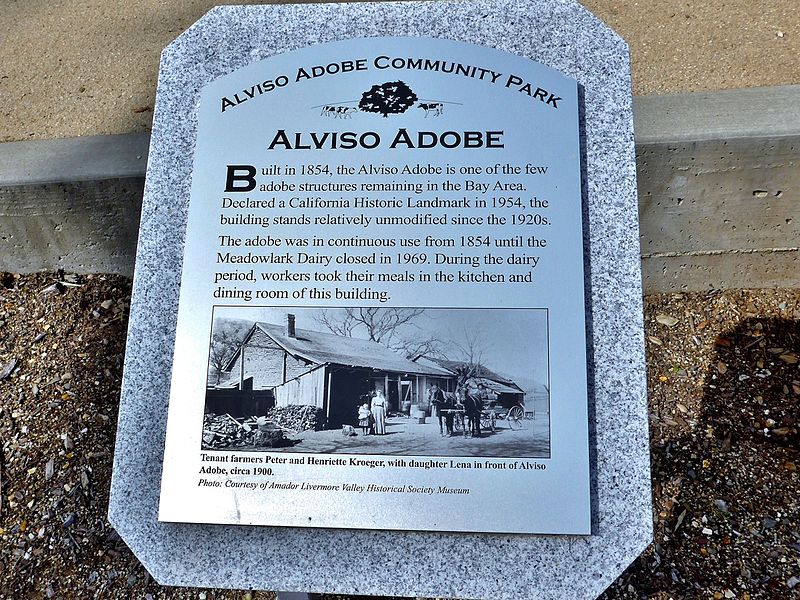
The Alviso Adobe Community Park is a 7-acre park in the city of Pleasanton, California, United States. It is built around an adobe house constructed in 1854 by Francisco Alviso on the Rancho Santa Rita Mexican Land Grant. The Alviso Adobe is a rare surviving example of an early American adobe that was continuously in use until 1969. The building is registered as California Historical Landmark #510 in 1954, but most of the historical marker was later found to be erroneous. ()
Built: 1854 (172 years ago)Elevation: 371 ft a.s.l.Coordinates: 37°39'38"N, 121°54'43"W
Getting there by public transportation
Public transportation stops near this location
- Bus
 Bus
Bus
- Calculate route6900 Koll Center Parkway 15 min walk
- Calculate route6700 Koll Center Parkway 15 min walk
- Calculate routeKoll Center Parkway & Koll Center Drive 17 min walk
- Calculate routeValley Avenue & Koll Center Parkway 21 min walk
Day trips


Frequently Asked Questions (FAQ)
How to get to Alviso Adobe Community Park by public transport?
The nearest stations to Alviso Adobe Community Park:
Bus
Bus
- 6900 Koll Center Parkway • Lines: 54 (15 min walk)
- 6700 Koll Center Parkway • Lines: 54 (15 min walk)