Bullitt Center, Seattle

Gallery (1)
Map

Map
Facts and practical information
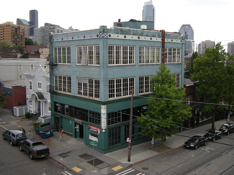
The Bullitt Center is a commercial office building at the intersection of the Central District neighborhood, and Capitol Hill, Seattle, Washington. It was officially opened on Earth Day, April 22, 2013. The Bullitt Center was designed to be the greenest commercial building in the world, and was certified as a "Living Building" by the International Living Future Institute in April 2015. ()
Coordinates: 47°36'51"N, 122°18'45"W
Address
Central Seattle (Central District)Seattle
ContactAdd
Social media
Add
Getting there by public transportation
Public transportation stops near this location
- Bus
- Trolleybus
- Tram
- Light rail
- Train
 Bus
Bus
- Calculate routeE Pine St & 15th Ave 2 min walk
- Calculate routeE Madison St & 17th Ave 4 min walk
- Calculate routeBroadway & Pike 10 min walk
- Calculate routeCapitol Hill 13 min walk
- Calculate routeWestlake 29 min walk
- Calculate routeUniversity Street 31 min walk
- Calculate routePioneer Square 31 min walk
- Calculate routeWestlake Center 30 min walk
- Calculate routeSeattle King Street 36 min walk
- Calculate route3rd Ave & Seneca St 30 min walk
- Calculate routePrefontaine Pl S & Yesler Way 31 min walk
Day trips


Frequently Asked Questions (FAQ)
Which popular attractions are close to Bullitt Center?
Nearby attractions include Temple De Hirsch Sinai, Seattle (2 min walk), Renton Hill, Seattle (6 min walk), Cal Anderson Park, Seattle (10 min walk), First Methodist Protestant Church of Seattle, Seattle (10 min walk).
How to get to Bullitt Center by public transport?
The nearest stations to Bullitt Center:
Bus
Tram
Light rail
Train
Trolleybus
Bus
- E Pine St & 15th Ave • Lines: 11 (2 min walk)
- E Madison St & 17th Ave • Lines: 11 (4 min walk)
Tram
- Broadway & Pike • Lines: First Hill Streetcar (10 min walk)
Light rail
- Capitol Hill • Lines: 1 (13 min walk)
- Westlake • Lines: 1 (29 min walk)
Train
- Westlake Center (30 min walk)
- Seattle King Street (36 min walk)
Trolleybus
- 3rd Ave & Seneca St • Lines: 1, 13, 3, 4, 49 (30 min walk)
- Prefontaine Pl S & Yesler Way • Lines: 1, 13, 49 (31 min walk)